Geolocate

Fall River topographic map

Click on the map to display elevation.

About this map

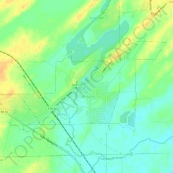
Name: Fall River topographic map, elevation, terrain.

Location: Fall River, Columbia County, Wisconsin, United States (43.37619 -89.07464 43.39733 -89.01966)

Average elevation: 266 m

Minimum elevation: 253 m

Maximum elevation: 285 m

Other topographic maps

Click on a map to view its topography, its elevation and its terrain.

Fall River

United States > Wisconsin > Columbia County

Average elevation: 266 m

Dekorra

United States > Wisconsin > Columbia County

Average elevation: 259 m

Englewood

United States > Wisconsin > Columbia County

Average elevation: 276 m

Gear up for your next adventure:

🔥Camping Stove - Portable stoves to cook outdoors with ease
🧥Fleece Jacket - Warm and lightweight jacket for layering
🪜Heavy Duty Carabiners - Multi-use clips for securing gear to your backpack
🧢Sun Protection Cap - Breathable cap to protect from sun exposure
🧢Beanie Hat - Keep your head warm in cold weather

As an Amazon Associate, this site earns from qualifying purchases at no extra cost to you.