Geolocate

Portage topographic map

Click on the map to display elevation.

About this map

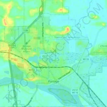
Name: Portage topographic map, elevation, terrain.

Location: Portage, Columbia County, Wisconsin, 53901, United States (43.52530 -89.50737 43.58430 -89.43087)

Average elevation: 244 m

Minimum elevation: 235 m

Maximum elevation: 271 m

Other topographic maps

Click on a map to view its topography, its elevation and its terrain.

Fall River

United States > Wisconsin > Columbia County

Average elevation: 266 m

Dekorra

United States > Wisconsin > Columbia County

Average elevation: 259 m

Englewood

United States > Wisconsin > Columbia County

Average elevation: 276 m

Gear up for your next adventure:

🏃Hydration Running Vest - Carry water and maps close to your body for speed
🪜Heavy Duty Carabiners - Multi-use clips for securing gear to your backpack
🔪Outdoor Multitool - Versatile tool for repairs and food prep in the wild
🥾Trekking Boots - Durable boots for long-distance trekking
🧴Waterproofing Spray - Restore the DWR coating on jackets and tents

As an Amazon Associate, this site earns from qualifying purchases at no extra cost to you.