Geneva topographic map
Click on the map to display elevation.
About this map
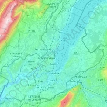
Name: Geneva topographic map, elevation, terrain.
Location: Geneva, Switzerland (46.12855 5.95591 46.36457 6.31029)
Average elevation: 522 m
Minimum elevation: 342 m
Maximum elevation: 1,678 m
Other topographic maps
Click on a map to view its topography, its elevation and its terrain.
Matterhorn
Switzerland > Valais/Wallis > Visp > Zermatt
In 1999, the summit height was precisely determined to be at 4,477.54 m (14,690 ft) above sea level by using Global Positioning System technology as part of the TOWER Project (Top of the World Elevations Remeasurement) and to an accuracy of less than one centimetre, which allows future changes to be tracked.
Average elevation: 3,295 m



Oeschinen Lake
Switzerland > Bern > Frutigen-Niedersimmental administrative district > Kandersteg
Oeschinen Lake (German: Oeschinensee) is a lake in the Bernese Oberland, Switzerland, 4 kilometres (2.5 mi) east of Kandersteg in the Oeschinen valley. At an elevation of 1,578 metres (5,177 ft), it has a surface area of 1.1147 square kilometres (0.4304 sq mi). Its maximum depth is 56 metres (184 ft).
Average elevation: 1,918 m



La Dôle
Switzerland > Vaud > District de Nyon > Gingins
La Dôle (French pronunciation: [la dol]) is a mountain of the Jura, overlooking Lake Geneva in the westernmost part of the canton of Vaud. Rising to an altitude of 1677 meters, it is the second highest peak in the Swiss portion of the Jura, after Mont Tendre. Administratively, the summit is split between the…
Average elevation: 1,435 m



Leuggelbach
Switzerland > Glarus > Glarus Süd
Leuggelbach is located in the valley of the Linth river, with the village situated on the west bank of the river at an elevation of approximately 554 m (1,818 ft). Luchsingen lies to the south, Nidfurn is to the north, and Haslen is across the river to the north and east.
Average elevation: 990 m



Läger-Oberberg
Switzerland > Bern > Interlaken-Oberhasli administrative district > Bönigen
Average elevation: 1,630 m
Passo del Bernina
Switzerland > Grisons > Bernina > Poschiavo
The building of the road began in 1842. Head of engineers was Rudolf Albertini (1821–1896) from Zuoz. The work was finished in 1865 and a hospice at an elevation of 2,307 metres (7,569 ft) was also opened. Since this time the road has been widened several times. Since 1965 it has been open all year round,…
Average elevation: 2,291 m
Wildhaus
Switzerland > St. Gallen > Wahlkreis Toggenburg > Wildhaus-Alt St. Johann
Average elevation: 1,244 m


Gstaad
Switzerland > Bern > Obersimmental-Saanen administrative district
Long known for its walking and hiking trails of varying degrees of difficulty, the mountain air and ambiance attract guests year-round from around the world. Gstaad is also known for its ski and cross-country slopes and winter hiking trails. Glacier 3000 is a major attraction, offering guaranteed snow from…
Average elevation: 1,245 m
Elm
Switzerland > Glarus > Glarus Süd
The village of Elm is situated at an elevation of 977 m (3,205 ft) on the left bank of the Sernf river. It is the farthest village upstream in the valley of the Sernf, with the village of Matt downstream and to the north. Elm lies on the road from Schwanden, although the road continues higher up the valley to…
Average elevation: 1,388 m


Gilbach
Switzerland > Bern > Frutigen-Niedersimmental administrative district > Adelboden
Average elevation: 1,609 m


Grosse Scheidegg
Switzerland > Bern > Interlaken-Oberhasli administrative district > Grindelwald
Average elevation: 1,967 m
Birg
Switzerland > Bern > Interlaken-Oberhasli administrative district > Lauterbrunnen
Average elevation: 2,311 m



Castor
Switzerland > Valais/Wallis > Visp > Zermatt
Castor (Italian: Castore) is a mountain in the Pennine Alps on the border between Valais, Switzerland and the Aosta Valley in Italy. It is the higher of a pair of twin peaks (German: Zwillinge), the other being Pollux, named after the Gemini twins of Roman mythology. Castor's peak is at an elevation of 4,225 m…
Average elevation: 3,721 m

Piz Bernina
Switzerland > Grisons > Maloja > Pontresina
Piz Bernina is one of the few isolated Alpine four-thousanders and the most topographically isolated mountain of Switzerland. It is the culminating point of a group of summits slightly lower than 4,000 m (13,123 ft) mostly lying on the main watershed between Switzerland and Italy (such as Piz Scerscen, Piz…
Average elevation: 3,362 m


Pianelli di Sotto
Switzerland > Ticino > Distretto di Vallemaggia > Campo (Vallemaggia)
Average elevation: 1,696 m


Eiger
Switzerland > Bern > Interlaken-Oberhasli administrative district > Grindelwald
Average elevation: 2,944 m


Val Sinestra
Switzerland > Grisons > Region Engiadina Bassa/Val Müstair > Scuol
Average elevation: 1,966 m
Jungfrau
Switzerland > Bern > Interlaken-Oberhasli administrative district > Lauterbrunnen
The difference of altitude between the deep valley of Lauterbrunnen (800 m or 2,600 ft) and the summit is particularly visible from the area of Mürren. From the valley floor, west of the massif, the altitude gain is more than 3 km (1.9 mi) for a horizontal distance of 4 km (2.5 mi).
Average elevation: 3,401 m
Monte Rosa
Switzerland > Wallis > Visp > Zermatt
The peak is distinguished by the name Dufourspitze (in German, lit. Dufour Peak; French: Pointe Dufour, Italian: Punta Dufour). This replaced the former name Höchste Spitze (English: Highest Peak) that was indicated on the Swiss maps before the Federal Council, on January 28, 1863, decided to rename the…
Average elevation: 4,033 m
Lausanne
Switzerland > Vaud > District de Lausanne > Lausanne
The most important geographical feature of the area surrounding Lausanne is Lake Geneva (Lac Léman in French). Lausanne is built on the southern slope of the Swiss plateau, with a difference in elevation of about 500 metres (1,640 ft) between the lakeshore at Ouchy and its northern edge bordering Le…
Average elevation: 577 m


Sool
Switzerland > Glarus > Glarus Süd
The village of Sool is situated at an elevation of 637 m (2,090 ft) on a prehistoric landslide, betwe the valleys of the Linth and Sernf rivers. The village of Schwanden lies below it, at the confluence of both rivers.
Average elevation: 860 m

Augstmatthorn
Switzerland > Bern > Interlaken-Oberhasli administrative district > Oberried am Brienzersee
Average elevation: 1,557 m

Eau-Rouge
Switzerland > Valais/Wallis > Entremont > Chamoille (Sembrancher) > Les Champmanins
Average elevation: 1,034 m


Valle Verzasca
Switzerland > Ticino > Distretto di Locarno > Verzasca
Located between the Leventina and the Valle Maggia valleys, Valle Verzasca extends over a length of 25 kilometres (16 mi) in north–south direction and is situated in the north of the Lago Maggiore. The valley floor is at about 500 metres (1,640 ft) to 900 metres (2,953 ft) above sea level. The surrounding…
Average elevation: 1,398 m
Hasliberg Wasserwendi
Switzerland > Bern > Interlaken-Oberhasli administrative district
Average elevation: 1,247 m


Klausenpass
Switzerland > Uri > Unterschächen
Klausen Pass (German: Klausenpass; elevation: 1,948 metres or 6,391 feet) is a high mountain pass in the Swiss Alps connecting Altdorf in the canton of Uri with Linthal in the canton of Glarus. Somewhat unusually, the boundary between the two cantons does not lie at the summit of the pass, but some 8…
Average elevation: 2,103 m
Brienz
Switzerland > Bern > Interlaken-Oberhasli administrative district > Brienz (BE)
Average elevation: 810 m

Monte Rosa
Switzerland > Wallis > Visp > Zermatt
The peak is distinguished by the name Dufourspitze (in German, lit. Dufour Peak; French: Pointe Dufour, Italian: Punta Dufour). This replaced the former name Höchste Spitze (English: Highest Peak) that was indicated on the Swiss maps before the Federal Council, on January 28, 1863, decided to rename the…
Average elevation: 4,033 m

Windegghoren
Switzerland > Bern > Interlaken-Oberhasli administrative district > Innertkirchen
Average elevation: 2,277 m
Jungfrau
Switzerland > Bern > Interlaken-Oberhasli administrative district > Lauterbrunnen
The difference of altitude between the deep valley of Lauterbrunnen (800 m or 2,600 ft) and the summit is particularly visible from the area of Mürren. From the valley floor, west of the massif, the altitude gain is more than 3 km (1.9 mi) for a horizontal distance of 4 km (2.5 mi).
Average elevation: 3,401 m