
Make a donation
Gear up for your next adventure:
As an Amazon Associate, this site earns from qualifying purchases at no extra cost to you.
Valle Verzasca topographic map
Click on the map to display elevation.
Make a donation
Gear up for your next adventure:
As an Amazon Associate, this site earns from qualifying purchases at no extra cost to you.
Valle Verzasca
Located between the Leventina and the Valle Maggia valleys, Valle Verzasca extends over a length of 25 kilometres (16 mi) in north–south direction and is situated in the north of the Lago Maggiore. The valley floor is at about 500 metres (1,640 ft) to 900 metres (2,953 ft) above sea level. The surrounding mountain passes respectively have an average altitude of 2,400 metres (7,874 ft). The Valley is crossed by the Verzasca river which is dammed at the southernly outlet of the Valley, forming the Lago di Vogorno, before it flows in the Magadino plain in the vicinity of the Ticino River in the Lago Maggiore.[1]
Make a donation
Gear up for your next adventure:
As an Amazon Associate, this site earns from qualifying purchases at no extra cost to you.
About this map
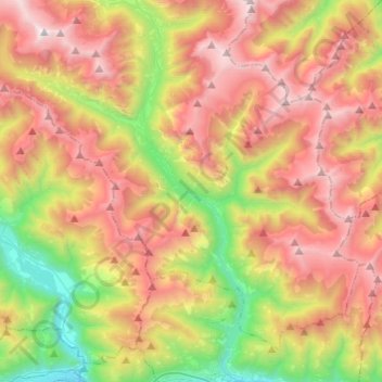
Name: Valle Verzasca topographic map, elevation, terrain.
Average elevation: 1,398 m
Minimum elevation: 217 m
Maximum elevation: 2,635 m
Make a donation
Gear up for your next adventure:
As an Amazon Associate, this site earns from qualifying purchases at no extra cost to you.