
Watauga County topographic map
Interactive map
Click on the map to display elevation.
About this map
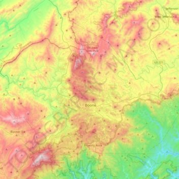
Name: Watauga County topographic map, elevation, terrain.
Location: Watauga County, North Carolina, United States (36.11147 -81.91812 36.39129 -81.45580)
Average elevation: 984 m
Minimum elevation: 378 m
Maximum elevation: 1,777 m
As with most of North Carolina's High Country, the climate of Watauga County is that of a Humid continental climate characterized by considerably cooler and more drastic weather than other parts of the state. Dramatic and unexpected changes in the weather are not uncommon in the county, particularly when it comes to precipitation. This is partly due to the elevation of the county, and partly due to orographic lifting, which causes precipitation to fall more readily in Watauga County than in lowland areas to the east. Summers can be very warm with temperatures commonly in the 80s and on a rare occasion in the 90s. Snow usually starts in November, and there can be snow falls in April, although this is not usual. Windy conditions tend to be amplified across the county due to the rugged terrain and high elevation. Many people have noted that the winters of Watauga County tend to resemble those of the northern United States instead of the South.
Other topographic maps
Click on a map to view its topography, its elevation and its terrain.
Charlotte
United States > North Carolina > Mecklenburg County
Charlotte, Mecklenburg County, North Carolina, United States
Average elevation: 207 m
Pamlico County
United States > North Carolina > Pamlico County
Pamlico County, North Carolina, United States
Average elevation: 5 m
South Mills
United States > North Carolina > Camden County
South Mills, Camden County, North Carolina, 27976, United States
Average elevation: 4 m
Murfreesboro
United States > North Carolina > Hertford County
Murfreesboro, Hertford County, North Carolina, 27855, United States
Average elevation: 21 m
White Plains
United States > North Carolina > Surry County
White Plains, Surry County, North Carolina, United States
Average elevation: 353 m
Glen Alpine
United States > North Carolina > Burke County
Glen Alpine, Burke County, North Carolina, 28628, United States
Average elevation: 347 m
Lake Lauderdale Dam
United States > North Carolina > Johnston County
Lake Lauderdale Dam, Johnston County, North Carolina, 27524, United States
Average elevation: 50 m
Surry County
United States > North Carolina
Surry County, North Carolina, United States
Average elevation: 394 m
Jamesville
United States > North Carolina > Martin County
Jamesville, Martin County, North Carolina, United States
Average elevation: 8 m
Shamrock Terrace
United States > North Carolina > Pitt County > Winterville
Shamrock Terrace, Winterville, Pitt County, North Carolina, 28590, United States
Average elevation: 22 m
Maiden
United States > North Carolina > Catawba County
Maiden, Catawba County, North Carolina, United States
Average elevation: 273 m
Jeffers Lake
United States > North Carolina > Henderson County
Jeffers Lake, Henderson County, North Carolina, United States
Average elevation: 800 m
Fayetteville
United States > North Carolina > Cumberland County
Fayetteville, Cumberland County, North Carolina, United States
Average elevation: 48 m
Lincoln Heights
United States > North Carolina > Guilford County > Greensboro
Lincoln Heights, Greensboro, Guilford County, North Carolina, 27401, United States
Average elevation: 234 m
Middle Mountain
United States > North Carolina > Transylvania County
Middle Mountain, Transylvania County, North Carolina, United States
Average elevation: 916 m
Jackson County
United States > North Carolina
Jackson County, North Carolina, United States
Average elevation: 979 m
Wilkesboro
United States > North Carolina > Wilkes County
Wilkesboro, Wilkes County, North Carolina, United States
Average elevation: 352 m
Grandfather Mountain State Park
United States > North Carolina > Watauga County > Banner Elk
Grandfather Mountain State Park, 9872, Banner Elk, Watauga County, North Carolina, 28604, United States
Average elevation: 1,293 m
Flat Rock
United States > North Carolina > Henderson County
Flat Rock, Henderson County, North Carolina, United States
Average elevation: 702 m
Stone Mountain State Park
United States > North Carolina > Wilkes County
Stone Mountain State Park, 3042, Wilkes County, North Carolina, 28668, United States
Average elevation: 641 m
Eno River State Park
United States > North Carolina > Orange County
Eno River State Park, Orange County, North Carolina, United States
Average elevation: 167 m
Gorges State Park
United States > North Carolina > Transylvania County
Gorges State Park, 976, Transylvania County, North Carolina, 28774, United States
Average elevation: 682 m
Hanging Rock State Park
United States > North Carolina > Stokes County > Danbury
Hanging Rock State Park, 1790, Danbury, Stokes County, North Carolina, 27016, United States
Average elevation: 323 m
Linden
United States > North Carolina > Cumberland County
Linden, Cumberland County, North Carolina, United States
Average elevation: 36 m
Patterson Lake
United States > North Carolina > Randolph County
Patterson Lake, Randolph County, North Carolina, United States
Average elevation: 216 m
Mortimer
United States > North Carolina > Caldwell County
Mortimer, Caldwell County, North Carolina, United States
Average elevation: 574 m
Hayesville
United States > North Carolina > Clay County
Hayesville, Clay County, North Carolina, United States
Average elevation: 573 m
Steep Pines Fork
United States > North Carolina > Carteret County > Beaufort
Steep Pines Fork, Beaufort, Carteret County, North Carolina, United States
Average elevation: 2 m
Colington
United States > North Carolina > Dare County
Colington, Dare County, North Carolina, 27948, United States
Average elevation: 1 m
Mount Airy
United States > North Carolina > Surry County
Mount Airy, Surry County, North Carolina, 27030, United States
Average elevation: 346 m
Holly Springs
United States > North Carolina > Wake County > Holly Springs
Holly Springs, Wake County, North Carolina, 27540, United States
Average elevation: 115 m
Lake Lure
United States > North Carolina > Rutherford County
Lake Lure, Rutherford County, North Carolina, 28746, United States
Average elevation: 363 m
Roaring River
United States > North Carolina > Wilkes County
Roaring River, Wilkes County, North Carolina, United States
Average elevation: 362 m
Beach Mountain
United States > North Carolina > Clay County
Beach Mountain, Clay County, North Carolina, 28909, United States
Average elevation: 618 m
Madison Park
United States > North Carolina > Person County > Roxboro
Madison Park, Roxboro, Person County, North Carolina, 27574, United States
Average elevation: 192 m
Macon County
United States > North Carolina
Macon County, North Carolina, United States
Average elevation: 904 m
Franklin County
United States > North Carolina
Franklin County, North Carolina, United States
Average elevation: 92 m
Rowan County
United States > North Carolina
Rowan County, North Carolina, United States
Average elevation: 228 m
2388
United States > North Carolina > Yancey County > Burnsville
2388, Burnsville, Yancey County, North Carolina, 28714, United States, Mount Mitchell State Park
Average elevation: 1,274 m
Cates
United States > North Carolina > Person County
Cates, Person County, North Carolina, 27583, United States
Average elevation: 181 m
Brevard
United States > North Carolina > Transylvania County
Brevard, Transylvania County, North Carolina, United States
Average elevation: 745 m
Dixie
United States > North Carolina > Mecklenburg County
Dixie, Mecklenburg County, North Carolina, 29012, United States
Average elevation: 198 m
Pasquotank County
United States > North Carolina
Pasquotank County, North Carolina, United States
Average elevation: 3 m
Efland
United States > North Carolina > Orange County
Efland, Orange County, North Carolina, 27243, United States
Average elevation: 193 m
Huntersville
United States > North Carolina > Mecklenburg County
Huntersville, Mecklenburg County, North Carolina, United States
Average elevation: 226 m
Saluda
United States > North Carolina > Polk County
Saluda, Polk County, North Carolina, 28773, United States
Average elevation: 635 m
Madison County
United States > North Carolina
Madison County, North Carolina, United States
Average elevation: 802 m
Henderson County
United States > North Carolina
Henderson County, North Carolina, United States
Average elevation: 703 m
Hamlet
United States > North Carolina > Richmond County
Hamlet, Richmond County, North Carolina, 28345, United States
Average elevation: 103 m
Wake Forest
United States > North Carolina > Wake County
Wake Forest, Wake County, North Carolina, 27588, United States
Average elevation: 105 m