
Make a donation
Gear up for your next adventure:
As an Amazon Associate, this site earns from qualifying purchases at no extra cost to you.
Charlotte topographic map
Click on the map to display elevation.
Make a donation
Gear up for your next adventure:
As an Amazon Associate, this site earns from qualifying purchases at no extra cost to you.
Charlotte
According to the United States Census Bureau, the city has a total area of 312.00 square miles (808.1 km2), of which 310.02 square miles (802.9 km2) is land and 1.98 square miles (5.1 km2) (0.63%) is water. Charlotte is the twenty-sixth-most expansive city in the United States and lies at an elevation of 751 feet (229 m). Charlotte constitutes most of Mecklenburg County in the Carolina Piedmont. Uptown Charlotte sits atop a long rise between two creeks, Sugar Creek and Irwin Creek, and was built on the gunnies of the St. Catherine's and Rudisill gold mines. Charlotte is 25 miles (40 km) southwest of Concord, 26 miles (42 km) northeast of Rock Hill, South Carolina, 83 miles (134 km) southwest of Greensboro, 135 miles (217 km) west of Fayetteville, and 165 miles (266 km) southwest of Raleigh, the state capital.
Make a donation
Gear up for your next adventure:
As an Amazon Associate, this site earns from qualifying purchases at no extra cost to you.
About this map
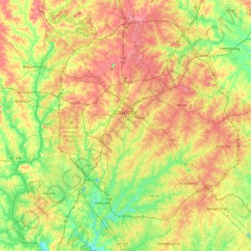
Name: Charlotte topographic map, elevation, terrain.
Location: Charlotte, Mecklenburg County, North Carolina, United States (35.01052 -81.01170 35.40025 -80.63488)
Average elevation: 207 m
Minimum elevation: 152 m
Maximum elevation: 271 m
Make a donation
Gear up for your next adventure:
As an Amazon Associate, this site earns from qualifying purchases at no extra cost to you.
Other topographic maps
Click on a map to view its topography, its elevation and its terrain.
Providence Plantation
United States > North Carolina > Mecklenburg County > Charlotte
Average elevation: 205 m
Reedy Creek Regional Park
United States > North Carolina > Mecklenburg County > Charlotte
Average elevation: 229 m
Tuckaseegee Park
United States > North Carolina > Mecklenburg County > Charlotte
Average elevation: 233 m
Make a donation
Gear up for your next adventure:
As an Amazon Associate, this site earns from qualifying purchases at no extra cost to you.
Ballantyne's Backyard
United States > North Carolina > Mecklenburg County > Charlotte
Average elevation: 183 m
Spring Valley
United States > North Carolina > Mecklenburg County > Charlotte
Average elevation: 201 m
Make a donation
Gear up for your next adventure:
As an Amazon Associate, this site earns from qualifying purchases at no extra cost to you.
Sharon Colony
United States > North Carolina > Mecklenburg County > Charlotte
Average elevation: 201 m
Carolina Harbor
United States > North Carolina > Mecklenburg County > Charlotte
Average elevation: 187 m
Make a donation
Gear up for your next adventure:
As an Amazon Associate, this site earns from qualifying purchases at no extra cost to you.
Morning Star Acres
United States > North Carolina > Mecklenburg County > Charlotte
Average elevation: 206 m
Make a donation
Gear up for your next adventure:
As an Amazon Associate, this site earns from qualifying purchases at no extra cost to you.
Make a donation
Gear up for your next adventure:
As an Amazon Associate, this site earns from qualifying purchases at no extra cost to you.
Griffith Lakes
United States > North Carolina > Mecklenburg County > Charlotte
Average elevation: 244 m
Make a donation
Gear up for your next adventure:
As an Amazon Associate, this site earns from qualifying purchases at no extra cost to you.
Park on Wilgrove
United States > North Carolina > Mecklenburg County > Charlotte > Lakeland Hills
Average elevation: 232 m
Make a donation
Gear up for your next adventure:
As an Amazon Associate, this site earns from qualifying purchases at no extra cost to you.
Providence Plantation
United States > North Carolina > Mecklenburg County > Charlotte
Average elevation: 205 m
Providence Plantation
United States > North Carolina > Mecklenburg County > Charlotte
Average elevation: 205 m
Old Providence
United States > North Carolina > Mecklenburg County > Charlotte
Average elevation: 192 m
Make a donation
Gear up for your next adventure:
As an Amazon Associate, this site earns from qualifying purchases at no extra cost to you.
Montclaire South
United States > North Carolina > Mecklenburg County > Charlotte
Average elevation: 202 m
Make a donation
Gear up for your next adventure:
As an Amazon Associate, this site earns from qualifying purchases at no extra cost to you.
Coulwood Hills
United States > North Carolina > Mecklenburg County > Charlotte > Coulwood Hills
Average elevation: 213 m