Geolocate

Saran topographic map

Click on the map to display elevation.

About this map

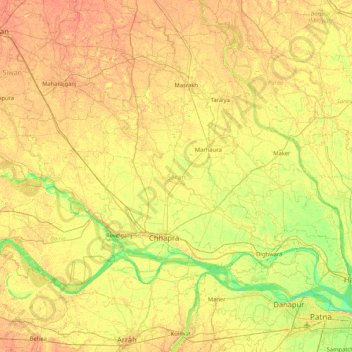
Name: Saran topographic map, elevation, terrain.

Location: Saran, Bihar, India (25.59907 84.40440 26.21896 85.23863)

Average elevation: 56 m

Minimum elevation: 39 m

Maximum elevation: 69 m

Other topographic maps

Click on a map to view its topography, its elevation and its terrain.

Danapur

India > Bihar > Dinapur-Cum-Khagaul

Average elevation: 52 m

Rusera

India > Bihar > Rosera

Average elevation: 45 m

Kuari

India > Bihar > Dhamdaha

Average elevation: 37 m

Singheswar

India > Bihar > Singheshwar

Average elevation: 47 m

Maheshkhunt

India > Bihar > Gogri

Average elevation: 36 m

Runisaidpur

India > Bihar > Runisaidpur

Average elevation: 58 m

Kishanpur

India > Bihar > Kishanpur

Average elevation: 55 m

Bhimpur

India > Bihar > Madhepur > Bhimpur

Average elevation: 49 m

Mohanpur

India > Bihar > Mohanpur

Average elevation: 122 m

Raxaul

India > Bihar > Raxaul

Average elevation: 81 m

Gear up for your next adventure:

🥾Mountain Hiking Boots - High-traction boots for rocky terrain
🌬️Windproof Camp Stove - Efficient cooking even on exposed mountain peaks
🧭Orienteering Kit - Tools for map reading and navigation in the wild
🔪Outdoor Multitool - Versatile tool for repairs and food prep in the wild
🥾Mountain Hiking Shoes - Shoes with superior grip for mountainous terrain

As an Amazon Associate, this site earns from qualifying purchases at no extra cost to you.