Geolocate

Mohanpur topographic map

Click on the map to display elevation.

About this map

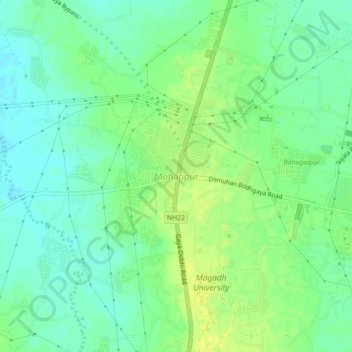
Name: Mohanpur topographic map, elevation, terrain.

Location: Mohanpur, Bodh Gaya, Gaya, Bihar, 823004, India (24.67922 84.94132 24.71922 84.98132)

Average elevation: 122 m

Minimum elevation: 113 m

Maximum elevation: 131 m

Gear up for your next adventure:

🏃Hydration Running Vest - Carry water and maps close to your body for speed
👟Leg Gaiters - Keep debris, mud, and snow out of your boots
🗺️Topographic Maps - Detailed maps to explore trails, mountains, and wilderness areas
🕯️Camping Lantern - Illuminates your entire campsite with high-efficiency LEDs
🐕Hiking Dog Pack - Let your canine companion carry their own water and food

As an Amazon Associate, this site earns from qualifying purchases at no extra cost to you.