
Hunterdon County topographic map
Interactive map
Click on the map to display elevation.
Hunterdon County
Much of the county is hilly, with several hills rising to one thousand foot in elevation. The highest points are two areas in Lebanon Township, one on the Morris County line, both reaching approximately 1,060 feet (320 m) above sea level. The first is at Smith on the Morris County line and the second is north of the area called Little Brook. This area is known as the Highlands of New Jersey. The lowest elevation is where the Mercer County line reaches the Delaware River, approximately 50 feet (15 m) above sea level. The county is drained by the Musconetcong River in the north. The river flows in a southwest direction. The Lamington River drains the county in the east. The central portion of the county is drained by the South Branch of the Raritan River. The Delaware River drains the western side of the county.
About this map
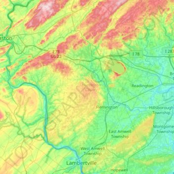
Name: Hunterdon County topographic map, elevation, terrain.
Location: Hunterdon County, New Jersey, United States (40.33943 -75.19554 40.78909 -74.70369)
Average elevation: 120 m
Minimum elevation: 10 m
Maximum elevation: 384 m
Other topographic maps
Click on a map to view its topography, its elevation and its terrain.
Verona
United States > New Jersey > Essex County
Verona has a humid continental climate (Dfa), with warm/hot humid summers and moderately cold winters. The climate is slightly cooler overall than in New York City, especially at night, because there is no urban heat island effect, as well as higher elevation and a more interior location (greater distance away…
Average elevation: 141 m
Deer Park Pond
United States > New Jersey > Warren County > Allamuchy Township
Average elevation: 282 m
Robbinsville
United States > New Jersey > Mercer County > Robbinsville Township
Average elevation: 32 m
Bernardsville
United States > New Jersey > Somerset County
Bernardsville has a climate that borders between Humid continental and Humid subtropical with cool sometimes cold winters and warm to hot, humid summers on average. High elevations of the town have a warm summer humid continental climate with more snow during the winter and more orographic precipitation.…
Average elevation: 142 m
Atlantic City
United States > New Jersey > Atlantic County
The city was incorporated in 1854, the same year train service began on the Camden and Atlantic Railroad. Built on the edge of the bay, this served as the direct link of this remote parcel of land with Philadelphia, the sixth-largest city in the United States and largest city in Pennsylvania. The same year,…
Average elevation: 1 m
Leonia
United States > New Jersey > Bergen County
While the borough center's elevation is 115 feet (35 m), the western part of the borough can reach 5 feet (1.5 m) and the eastern part of Leonia reaches 318 feet (97 m).
Average elevation: 35 m
Hudson County
The topography is marked by the New Jersey Palisades in the north with cliffs overlooking the Hudson to the east and less severe cuesta, or slope, to the west. They gradually level off to the southern peninsula, which is coastal and flat. The western region, around the Hackensack and Passaic is part of the New…
Average elevation: 12 m
Whitehouse Station
United States > New Jersey > Hunterdon County > Readington Township
Average elevation: 61 m
Weehawken
United States > New Jersey > Hudson County
While the Palisades defines Weehawken's natural topography, the Lincoln Tunnel Helix is prominent man-made and Lincoln Tunnel toll plaza are prominent man-made structures. Geographically, Weehawken has distinct neighborhoods: Downtown (known as "The Shades"), the Heights, Uptown (which includes Kingswood…
Average elevation: 27 m
Woodbridge
United States > New Jersey > Middlesex County > Woodbridge Township
Average elevation: 16 m
Union County
Much of Union County is relatively flat and low-lying. Only in the northwestern corner does any significant relief appear as the Watchung Mountains cross the county. It is there that highest elevations, two areas approximately 560 feet (170 m) above sea level, are found in Berkeley Heights. The lowest…
Average elevation: 45 m
North Bergen
United States > New Jersey > Hudson County
North Bergen has diverse geological features. Partially situated on the Hudson River, the Hudson Palisades rise from the waterfront, while the northern part of the town sits atop the plateau. The cuesta, or slope, on its west side makes North Bergen the city with the second-most hills per square mile in the…
Average elevation: 22 m
Atlantic Highlands
United States > New Jersey > Monmouth County
Atlantic Highlands has a humid subtropical climate (Cfa) and average monthly temperatures range from 32.6 °F (0.3 °C) in January to 75.9 °F (24.4 °C) in July. The hardiness zone is 7a or 7b depending upon elevation.
Average elevation: 9 m
Delaware Water Gap
United States > New Jersey > Warren County > Hardwick Township > Dunnfield
Average elevation: 246 m
Newark
United States > New Jersey > Essex County
According to the United States Census Bureau, the city had a total area of 25.89 square miles (67.1 km2), including 24.14 square miles (62.5 km2) of land and 1.74 square miles (4.5 km2) of water (6.72%). It has the third-smallest land area among the 100 most populous cities in the U.S., behind neighboring…
Average elevation: 22 m
Red Rock Lake
United States > New Jersey > Hunterdon County > Rockefellows Mills
Average elevation: 42 m
Harker's Hollow Heights
United States > New Jersey > Warren County > Lopatcong Township
Average elevation: 161 m
Chadwick Beach
United States > New Jersey > Ocean County > Toms River > Dover Beaches North
Average elevation: 0 m