
Hamilton Township topographic map
Click on the map to display elevation.
About this map
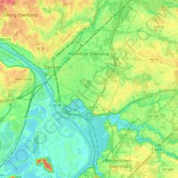
Name: Hamilton Township topographic map, elevation, terrain.
Location: Hamilton Township, Mercer County, New Jersey, United States (40.13684 -74.75277 40.27090 -74.58801)
Average elevation: 23 m
Minimum elevation: -1 m
Maximum elevation: 49 m
Other topographic maps
Click on a map to view its topography, its elevation and its terrain.
Robbinsville
United States > New Jersey > Mercer County > Robbinsville Township
Average elevation: 32 m
Princeton Colonial Park
United States > New Jersey > Mercer County > West Windsor
Average elevation: 29 m