
Carteret topographic map
Click on the map to display elevation.
About this map
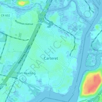
Name: Carteret topographic map, elevation, terrain.
Location: Carteret, Middlesex County, New Jersey, 07008, United States (40.55706 -74.25470 40.60407 -74.20360)
Average elevation: 6 m
Minimum elevation: -6 m
Maximum elevation: 51 m
Other topographic maps
Click on a map to view its topography, its elevation and its terrain.
Fairview Knolls
United States > New Jersey > Middlesex County > East Brunswick Township
Average elevation: 31 m
Woodbridge
United States > New Jersey > Middlesex County > Woodbridge Township
Average elevation: 16 m
Sayreville Junction
United States > New Jersey > Middlesex County > Sayreville
Average elevation: 17 m
South River
United States > New Jersey > Middlesex County > South River > South River
Average elevation: 19 m