
Hudson County topographic map
Click on the map to display elevation.
Hudson County
The topography is marked by the New Jersey Palisades in the north with cliffs overlooking the Hudson to the east and less severe cuesta, or slope, to the west. They gradually level off to the southern peninsula, which is coastal and flat. The western region, around the Hackensack and Passaic is part of the New Jersey Meadowlands. Much of the land along the county's extensive shoreline and littoral zone was created by land reclamation.
About this map
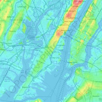
Name: Hudson County topographic map, elevation, terrain.
Location: Hudson County, New Jersey, United States (40.64199 -74.16600 40.82357 -73.98487)
Average elevation: 12 m
Minimum elevation: -9 m
Maximum elevation: 98 m
Other topographic maps
Click on a map to view its topography, its elevation and its terrain.
Deer Park Pond
United States > New Jersey > Warren County > Allamuchy Township
Average elevation: 282 m
Robbinsville
United States > New Jersey > Mercer County > Robbinsville Township
Average elevation: 32 m
Fairview Knolls
United States > New Jersey > Middlesex County > East Brunswick Township
Average elevation: 31 m
Whitehouse Station
United States > New Jersey > Hunterdon County > Readington Township
Average elevation: 61 m
Harker's Hollow Heights
United States > New Jersey > Warren County > Lopatcong Township
Average elevation: 161 m
Red Rock Lake
United States > New Jersey > Hunterdon County > Rockefellows Mills
Average elevation: 42 m
Delaware Water Gap
United States > New Jersey > Warren County > Hardwick Township > Dunnfield
Average elevation: 246 m
Woodbridge
United States > New Jersey > Middlesex County > Woodbridge Township
Average elevation: 16 m
Princeton Colonial Park
United States > New Jersey > Mercer County > West Windsor
Average elevation: 29 m
Chadwick Beach
United States > New Jersey > Ocean County > Toms River > Dover Beaches North
Average elevation: 0 m
Sayreville Junction
United States > New Jersey > Middlesex County > Sayreville
Average elevation: 17 m
Candlewood
United States > New Jersey > Monmouth County > Howell Township > Candlewood
Average elevation: 33 m
Columbia Lake
United States > New Jersey > Warren County > Knowlton Township > Warrington
Average elevation: 117 m
Butterworth Farms
United States > New Jersey > Morris County > Morris Township
Average elevation: 182 m
Swinefield Bridge
United States > New Jersey > Morris County > East Hanover > Swinefield Bridge
Average elevation: 63 m
High Crest Lake
United States > New Jersey > Passaic County > West Milford > Smiths Mills
Average elevation: 219 m
South River
United States > New Jersey > Middlesex County > South River > South River
Average elevation: 19 m