
Thank you for supporting this site ❤️
Make a donation
Make a donation
Gear up for your next adventure:
As an Amazon Associate, this site earns from qualifying purchases at no extra cost to you.
Ringwood topographic map
Click on the map to display elevation.
Thank you for supporting this site ❤️
Make a donation
Make a donation
Gear up for your next adventure:
As an Amazon Associate, this site earns from qualifying purchases at no extra cost to you.
About this map
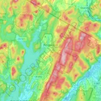
Name: Ringwood topographic map, elevation, terrain.
Location: Ringwood, Passaic County, New Jersey, 07456, United States (41.05110 -74.34640 41.16306 -74.21310)
Average elevation: 176 m
Minimum elevation: 70 m
Maximum elevation: 351 m
Thank you for supporting this site ❤️
Make a donation
Make a donation
Gear up for your next adventure:
As an Amazon Associate, this site earns from qualifying purchases at no extra cost to you.
Other topographic maps
Click on a map to view its topography, its elevation and its terrain.
High Crest Lake
United States > New Jersey > Passaic County > West Milford > Smiths Mills
Average elevation: 219 m