Geolocate

Pragelato topographic map

Click on the map to display elevation.

About this map

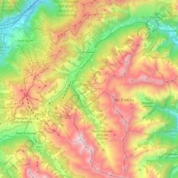
Name: Pragelato topographic map, elevation, terrain.

Location: Pragelato, Torino, Piedmont, Italy (44.89837 6.87101 45.06460 6.99417)

Average elevation: 2,052 m

Minimum elevation: 1,020 m

Maximum elevation: 3,253 m

Other topographic maps

Click on a map to view its topography, its elevation and its terrain.

Monte Vandalino

Italy > Piedmont > Torino > Villar Pellice

Average elevation: 1,634 m

Campiglia Soana

Italy > Piedmont > Torino

Average elevation: 1,797 m

Mompellato

Italy > Piedmont > Torino > Rubiana

Average elevation: 1,192 m

Tetti Valfrè

Italy > Piedmont > Torino > Orbassano

Average elevation: 255 m

La Ruà

Italy > Piedmont > Torino > Pragelato

Average elevation: 1,870 m

Pis Madai

Italy > Piedmont > Torino > Margone

Average elevation: 1,792 m

Malanghero

Italy > Piedmont > Torino > San Maurizio Canavese

Average elevation: 293 m

Piani

Italy > Piedmont > Torino > Sparone

Average elevation: 957 m

Cavoretto

Italy > Piedmont > Torino > Turin

Average elevation: 337 m

Roc

Italy > Piedmont > Torino > Prarostino

Average elevation: 510 m

Pian Rosa

Italy > Piedmont > Torino > Cuorgnè > Santa Lucia

Average elevation: 487 m

Grangia delle Alpi

Italy > Piedmont > Torino > Bussoleno

Average elevation: 778 m

Mollare

Italy > Piedmont > Torino > Gravere

Average elevation: 884 m

Valle Thuras

Italy > Piedmont > Torino > Sauze di Cesana

Average elevation: 2,414 m

Olivieri

Italy > Piedmont > Torino > Perrero

Average elevation: 1,136 m

Pattemouche

Italy > Piedmont > Torino > Pragelato

Average elevation: 1,912 m

Frieri

Italy > Piedmont > Torino > Villar Perosa

Average elevation: 753 m

Cappella Moreri

Italy > Piedmont > Torino > Bricherasio

Average elevation: 427 m

Pointe Sommeiller / Punta Sommeiller

Italy > Piedmont > Torino > Exilles

Punta Sommeiller (in Italian) or Pointe Sommeiller (in French) is a mountain of the Province of Turin, Italy and of Savoie, France. It lies in the Cottian Alps range. It has an elevation of 3,333 metres (10,935 ft) above sea level.

Average elevation: 2,975 m

Roncasso

Italy > Piedmont > Torino > Cuorgnè > Salto

Average elevation: 603 m

Gear up for your next adventure:

Lightweight Camping Tent - Portable shelter optimized for Canadian backcountry camping
🥾Lightweight Hiking Shoes - Comfortable shoes for day hikes
🔦UV Flashlight - Detect minerals or specific insects in the dark
🎒Fully Waterproof Backpack - Total protection for photography gear and electronics
🚲Heavy Duty Bike Lock - Secure your bike at the trailhead or during stops

As an Amazon Associate, this site earns from qualifying purchases at no extra cost to you.