Geolocate

Streetsboro topographic map

Click on the map to display elevation.

About this map

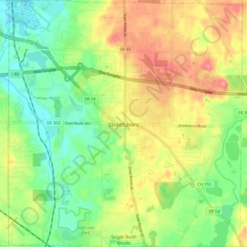
Name: Streetsboro topographic map, elevation, terrain.

Location: Streetsboro, Portage County, Ohio, 44241, United States (41.20234 -81.39213 41.27661 -81.29852)

Average elevation: 335 m

Minimum elevation: 300 m

Maximum elevation: 379 m

Gear up for your next adventure:

🌬️Windproof Camp Stove - Efficient cooking even on exposed mountain peaks
🥾Hiking Boots - Sturdy boots providing ankle support and traction on rugged trails
🥾Trail Running Boots - Durable shoes designed for trail running
🔥Camping Stove - Portable stoves to cook outdoors with ease
💡Portable Camping Lamp - Rechargeable lamp for campsite lighting

As an Amazon Associate, this site earns from qualifying purchases at no extra cost to you.