
Wilkes County topographic map
Interactive map
Click on the map to display elevation.
About this map
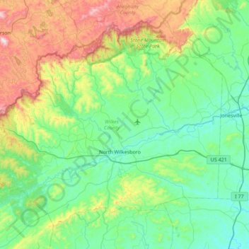
Name: Wilkes County topographic map, elevation, terrain.
Location: Wilkes County, North Carolina, United States (35.99484 -81.54549 36.44078 -80.86875)
Average elevation: 513 m
Minimum elevation: 248 m
Maximum elevation: 1,395 m
Wilkes County is located on the eastern slope of the Blue Ridge Mountains, a part of the Appalachian Mountains chain. The county's elevation ranges from 900 feet (375 meters) in the east to over 4,000 feet (1,219 meters) in the west. The Blue Ridge Mountains run from the southwest to the northeast, and dominate the county's western and northern horizons. Tomkins Knob, the highest point in the county, rises to 4,079 feet (1243 meters). The Blue Ridge Parkway runs along the crest of the Blue Ridge on the county's northern and western borders. The foothills and valleys of the Blue Ridge form most of the county's midsection, with some elevations exceeding 2,000 feet (610 meters). Stone Mountain State Park, located in the foothills of northern Wilkes County, is one of the most popular state parks in North Carolina, and is noted for its excellent rock climbing and trout fishing. The Brushy Mountains, an isolated spur of the Blue Ridge, form the county's southern border. Wilkes County's terrain gradually becomes more level and less hilly as one moves to the east; the far eastern section of the county lies within the Piedmont region of North Carolina. The largest river in Wilkes is the Yadkin River, which flows through the central part of the county. The county's three other major streams, all of which flow into the Yadkin, are the Reddies River, Roaring River, and Mulberry Creek. Following the devastating floods of 1916 and 1940, the US Army's Corps of Engineers constructed the W. Kerr Scott Dam and Reservoir on the Yadkin River four miles west of Wilkesboro. Opened in 1962, the dam created a lake with a shoreline of 56 miles. The lake is used for boating, swimming, fishing, and waterskiing; it is especially noted for its excellent bass fishing. The W. Kerr Scott lake is the largest body of water in Wilkes.
Other topographic maps
Click on a map to view its topography, its elevation and its terrain.
Topton
United States > North Carolina > Cherokee County
Topton, Cherokee County, North Carolina, United States
Average elevation: 980 m
Sherrills Ford
United States > North Carolina > Catawba County
Sherrills Ford, Catawba County, North Carolina, United States
Average elevation: 255 m
Charlotte
United States > North Carolina > Mecklenburg County
Charlotte, Mecklenburg County, North Carolina, United States
Average elevation: 207 m
Pamlico County
United States > North Carolina > Pamlico County
Pamlico County, North Carolina, United States
Average elevation: 5 m
South Mills
United States > North Carolina > Camden County
South Mills, Camden County, North Carolina, 27976, United States
Average elevation: 4 m
Murfreesboro
United States > North Carolina > Hertford County
Murfreesboro, Hertford County, North Carolina, 27855, United States
Average elevation: 21 m
White Plains
United States > North Carolina > Surry County
White Plains, Surry County, North Carolina, United States
Average elevation: 353 m
Glen Alpine
United States > North Carolina > Burke County
Glen Alpine, Burke County, North Carolina, 28628, United States
Average elevation: 347 m
Lake Lauderdale Dam
United States > North Carolina > Johnston County
Lake Lauderdale Dam, Johnston County, North Carolina, 27524, United States
Average elevation: 50 m
Surry County
United States > North Carolina
Surry County, North Carolina, United States
Average elevation: 394 m
Jamesville
United States > North Carolina > Martin County
Jamesville, Martin County, North Carolina, United States
Average elevation: 8 m
Shamrock Terrace
United States > North Carolina > Pitt County > Winterville
Shamrock Terrace, Winterville, Pitt County, North Carolina, 28590, United States
Average elevation: 22 m
Maiden
United States > North Carolina > Catawba County
Maiden, Catawba County, North Carolina, United States
Average elevation: 273 m
Jeffers Lake
United States > North Carolina > Henderson County
Jeffers Lake, Henderson County, North Carolina, United States
Average elevation: 800 m
Fayetteville
United States > North Carolina > Cumberland County
Fayetteville, Cumberland County, North Carolina, United States
Average elevation: 48 m
Lincoln Heights
United States > North Carolina > Guilford County > Greensboro
Lincoln Heights, Greensboro, Guilford County, North Carolina, 27401, United States
Average elevation: 234 m
Middle Mountain
United States > North Carolina > Transylvania County
Middle Mountain, Transylvania County, North Carolina, United States
Average elevation: 916 m
Jackson County
United States > North Carolina
Jackson County, North Carolina, United States
Average elevation: 979 m
Wilkesboro
United States > North Carolina > Wilkes County
Wilkesboro, Wilkes County, North Carolina, United States
Average elevation: 352 m
Grandfather Mountain State Park
United States > North Carolina > Watauga County > Banner Elk
Grandfather Mountain State Park, 9872, Banner Elk, Watauga County, North Carolina, 28604, United States
Average elevation: 1,293 m
Flat Rock
United States > North Carolina > Henderson County
Flat Rock, Henderson County, North Carolina, United States
Average elevation: 702 m
Stone Mountain State Park
United States > North Carolina > Wilkes County
Stone Mountain State Park, 3042, Wilkes County, North Carolina, 28668, United States
Average elevation: 641 m
Eno River State Park
United States > North Carolina > Orange County
Eno River State Park, Orange County, North Carolina, United States
Average elevation: 167 m
Gorges State Park
United States > North Carolina > Transylvania County
Gorges State Park, 976, Transylvania County, North Carolina, 28774, United States
Average elevation: 682 m
Hanging Rock State Park
United States > North Carolina > Stokes County > Danbury
Hanging Rock State Park, 1790, Danbury, Stokes County, North Carolina, 27016, United States
Average elevation: 323 m
Linden
United States > North Carolina > Cumberland County
Linden, Cumberland County, North Carolina, United States
Average elevation: 36 m
Patterson Lake
United States > North Carolina > Randolph County
Patterson Lake, Randolph County, North Carolina, United States
Average elevation: 216 m
Mortimer
United States > North Carolina > Caldwell County
Mortimer, Caldwell County, North Carolina, United States
Average elevation: 574 m
Hayesville
United States > North Carolina > Clay County
Hayesville, Clay County, North Carolina, United States
Average elevation: 573 m
Steep Pines Fork
United States > North Carolina > Carteret County > Beaufort
Steep Pines Fork, Beaufort, Carteret County, North Carolina, United States
Average elevation: 2 m
Colington
United States > North Carolina > Dare County
Colington, Dare County, North Carolina, 27948, United States
Average elevation: 1 m
Mount Airy
United States > North Carolina > Surry County
Mount Airy, Surry County, North Carolina, 27030, United States
Average elevation: 346 m
Holly Springs
United States > North Carolina > Wake County > Holly Springs
Holly Springs, Wake County, North Carolina, 27540, United States
Average elevation: 115 m
Lake Lure
United States > North Carolina > Rutherford County
Lake Lure, Rutherford County, North Carolina, 28746, United States
Average elevation: 363 m
Roaring River
United States > North Carolina > Wilkes County
Roaring River, Wilkes County, North Carolina, United States
Average elevation: 362 m
Beach Mountain
United States > North Carolina > Clay County
Beach Mountain, Clay County, North Carolina, 28909, United States
Average elevation: 618 m
Madison Park
United States > North Carolina > Person County > Roxboro
Madison Park, Roxboro, Person County, North Carolina, 27574, United States
Average elevation: 192 m
Macon County
United States > North Carolina
Macon County, North Carolina, United States
Average elevation: 904 m
Franklin County
United States > North Carolina
Franklin County, North Carolina, United States
Average elevation: 92 m
Rowan County
United States > North Carolina
Rowan County, North Carolina, United States
Average elevation: 228 m
2388
United States > North Carolina > Yancey County > Burnsville
2388, Burnsville, Yancey County, North Carolina, 28714, United States, Mount Mitchell State Park
Average elevation: 1,274 m
Cates
United States > North Carolina > Person County
Cates, Person County, North Carolina, 27583, United States
Average elevation: 181 m
Brevard
United States > North Carolina > Transylvania County
Brevard, Transylvania County, North Carolina, United States
Average elevation: 745 m
Dixie
United States > North Carolina > Mecklenburg County
Dixie, Mecklenburg County, North Carolina, 29012, United States
Average elevation: 198 m
Pasquotank County
United States > North Carolina
Pasquotank County, North Carolina, United States
Average elevation: 3 m
Efland
United States > North Carolina > Orange County
Efland, Orange County, North Carolina, 27243, United States
Average elevation: 193 m
Huntersville
United States > North Carolina > Mecklenburg County
Huntersville, Mecklenburg County, North Carolina, United States
Average elevation: 226 m
Saluda
United States > North Carolina > Polk County
Saluda, Polk County, North Carolina, 28773, United States
Average elevation: 635 m
Madison County
United States > North Carolina
Madison County, North Carolina, United States
Average elevation: 802 m
Henderson County
United States > North Carolina
Henderson County, North Carolina, United States
Average elevation: 703 m