Geolocate

Tvedestrand topographic map

Click on the map to display elevation.

About this map

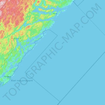
Name: Tvedestrand topographic map, elevation, terrain.

Location: Tvedestrand, Agder, Norway (58.42566 8.73307 58.70668 9.53165)

Average elevation: 75 m

Minimum elevation: -3 m

Maximum elevation: 503 m

Other topographic maps

Click on a map to view its topography, its elevation and its terrain.

Mandal

Norway > Agder

Average elevation: 38 m

Ausland

Norway > Agder > Gjerstad

Average elevation: 127 m

Lygna

Norway > Agder

Average elevation: 273 m

Dølemo

Norway > Agder

Average elevation: 254 m

Vanse

Norway > Agder > Farsund > Vanse

Average elevation: 28 m

Hovden

Norway > Agder

Average elevation: 875 m

Kvåfjord

Norway > Agder

Average elevation: 53 m

Gear up for your next adventure:

🎒Backpack Rain Cover - External shield to keep your entire pack dry
🔦UV Flashlight - Detect minerals or specific insects in the dark
🧴Sunscreen SPF - Broad-spectrum sunscreen for outdoor activities
🧴Insect Repellent - Protect yourself from bugs during outdoor adventures
🥾All-Terrain Hiking Boots - Versatile boots for varied hiking conditions

As an Amazon Associate, this site earns from qualifying purchases at no extra cost to you.