Geolocate

Kristiansand topographic map

Click on the map to display elevation.

About this map

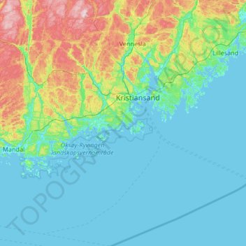
Name: Kristiansand topographic map, elevation, terrain.

Location: Kristiansand, Agder, Norway (57.80203 7.52730 58.36895 8.37168)

Average elevation: 76 m

Minimum elevation: -3 m

Maximum elevation: 474 m

Other topographic maps

Click on a map to view its topography, its elevation and its terrain.

Ausland

Norway > Agder > Gjerstad

Average elevation: 127 m

Lygna

Norway > Agder

Average elevation: 273 m

Dølemo

Norway > Agder

Average elevation: 254 m

Mandal

Norway > Agder

Average elevation: 38 m

Vanse

Norway > Agder > Farsund > Vanse

Average elevation: 28 m

Hovden

Norway > Agder

Average elevation: 875 m

Kvåfjord

Norway > Agder

Average elevation: 53 m

Gear up for your next adventure:

🧢Beanie Hat - Keep your head warm in cold weather
🧰Multitool Knife - Compact and versatile tool for outdoor use
🦶Hiking Shoe Insoles - Added support for high arches and long days on feet
🧤Thermal Hiking Gloves - Grip-enhanced gloves for cold-weather altitude trekking
🛏️Camping Sleeping Mat - Comfortable mats for sleeping outdoors

As an Amazon Associate, this site earns from qualifying purchases at no extra cost to you.