
Stillwater County topographic map
Interactive map
Click on the map to display elevation.
About this map
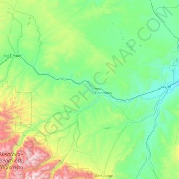
Name: Stillwater County topographic map, elevation, terrain.
Location: Stillwater County, Montana, United States (45.16718 -110.06592 46.13234 -108.84309)
Average elevation: 1,474 m
Minimum elevation: 981 m
Maximum elevation: 3,803 m
Other topographic maps
Click on a map to view its topography, its elevation and its terrain.
Bancroft Pond Nature Area
United States > Montana > Missoula County > Missoula
Average elevation: 1,005 m
Bozeman
United States > Montana > Gallatin County > Bozeman
Bozeman is located at an elevation of 4,820 feet (1,470 m). The Bridger Mountains are to the north-northeast, the Tobacco Root Mountains to the west-south-west, the Big Belt Mountains and Horseshoe Hills to the northwest, the Hyalite Peaks of the northern Gallatin Range to the south and the Spanish Peaks of…
Average elevation: 1,679 m