
Make a donation
Gear up for your next adventure:
As an Amazon Associate, this site earns from qualifying purchases at no extra cost to you.
Standing Rock topographic map
Click on the map to display elevation.
Make a donation
Gear up for your next adventure:
As an Amazon Associate, this site earns from qualifying purchases at no extra cost to you.
About this map
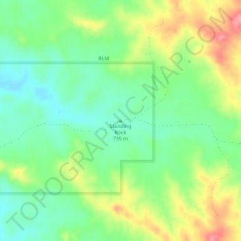
Name: Standing Rock topographic map, elevation, terrain.
Location: Standing Rock, Garfield County, Montana, United States (47.40578 -106.31953 47.40588 -106.31943)
Average elevation: 745 m
Minimum elevation: 707 m
Maximum elevation: 806 m
Make a donation
Gear up for your next adventure:
As an Amazon Associate, this site earns from qualifying purchases at no extra cost to you.
Other topographic maps
Click on a map to view its topography, its elevation and its terrain.
Kootenai National Forest
The Kootenai and the Clark Fork rivers are the major rivers and are fed by abundant rainfall that is more than double that amount found elsewhere in Montana. Three major hydroelectric dams exist in the Kootenai National Forest. Libby Dam on the Kootenai River creates a 90-mile (140 km)-long lake known as Lake…
Average elevation: 1,283 m
Make a donation
Gear up for your next adventure:
As an Amazon Associate, this site earns from qualifying purchases at no extra cost to you.
Butte
United States > Montana > Silver Bow County
Butte's South district, at a lower elevation than the hillside that comprises northern Butte, has historically been home to working-class neighborhoods. Gold mines originally populated south Butte before it was platted for the Union Pacific Railroad in 1881.
Average elevation: 1,909 m
Make a donation
Gear up for your next adventure:
As an Amazon Associate, this site earns from qualifying purchases at no extra cost to you.
Make a donation
Gear up for your next adventure:
As an Amazon Associate, this site earns from qualifying purchases at no extra cost to you.
Bancroft Pond Nature Area
United States > Montana > Missoula County > Missoula
Average elevation: 1,005 m
Make a donation
Gear up for your next adventure:
As an Amazon Associate, this site earns from qualifying purchases at no extra cost to you.
Thompson Falls
United States > Montana > Sanders County
Thompson Falls is located in the Clark Fork Valley at an elevation of 2,419 feet (737 m). The Clark Fork River flows on the southern side of town. It is next to the Cabinet Mountains.
Average elevation: 782 m
Make a donation
Gear up for your next adventure:
As an Amazon Associate, this site earns from qualifying purchases at no extra cost to you.
Make a donation
Gear up for your next adventure:
As an Amazon Associate, this site earns from qualifying purchases at no extra cost to you.
Sidney
United States > Montana > Richland County
Sidney is located in the northeastern part of the state at 47°43′00″N 104°09′23″W / 47.71667°N 104.15639°W / 47.71667; -104.15639 (47.7166836, -104.1563253), at an altitude of 1,942 feet (592 m).
Average elevation: 593 m
Make a donation
Gear up for your next adventure:
As an Amazon Associate, this site earns from qualifying purchases at no extra cost to you.
Woods Bay
United States > Montana > Lake County > Orchard Hills Mobile Home Park
Average elevation: 944 m
Make a donation
Gear up for your next adventure:
As an Amazon Associate, this site earns from qualifying purchases at no extra cost to you.
Big Sky
United States > Montana > Gallatin County
This climatic region is typified by large seasonal temperature differences, with warm to hot summers and cold (sometimes severely cold) winters. According to the Köppen Climate Classification system, Big Sky has a borderline humid continental (Dfb) / alpine subarctic climate (Dfc). for most of the area, but…
Average elevation: 2,435 m
Make a donation
Gear up for your next adventure:
As an Amazon Associate, this site earns from qualifying purchases at no extra cost to you.