
Morton County topographic map
Interactive map
Click on the map to display elevation.
About this map
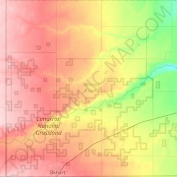
Name: Morton County topographic map, elevation, terrain.
Location: Morton County, Kansas, United States (36.99307 -102.04213 37.38919 -101.55524)
Average elevation: 1,050 m
Minimum elevation: 963 m
Maximum elevation: 1,132 m
Other topographic maps
Click on a map to view its topography, its elevation and its terrain.
Great Plains
United States > Kansas > Thomas County
The North American Environmental Atlas, produced by the Commission for Environmental Cooperation, a NAFTA agency composed of the geographical agencies of the Mexican, American, and Canadian governments, uses the "Great Plains" as an ecoregion synonymous with predominant prairies and grasslands rather than as…
Average elevation: 1,023 m
Mount Sunflower
United States > Kansas > Wallace County
Mount Sunflower, although not a true mountain, is the highest natural point in the U.S. state of Kansas. At 4,039 feet (1,231 m), it is 3,300 feet (1,010 m) above the state's topographic low point, which lies on the opposite side of the state. It is located between the communities of Kanorado and Weskan in…
Average elevation: 1,215 m