
Nakapiripirit topographic map
Interactive map
Click on the map to display elevation.
About this map
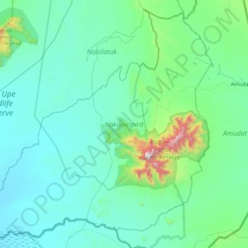
Name: Nakapiripirit topographic map, elevation, terrain.
Location: Nakapiripirit, Northern Region, Uganda (1.54922 34.22838 2.14912 34.87326)
Average elevation: 1,255 m
Minimum elevation: 1,048 m
Maximum elevation: 3,027 m
Other topographic maps
Click on a map to view its topography, its elevation and its terrain.
Bundibugyo
The geographical coordinates of Bundibugyo town are:0°42'45.0"N 30°03'36.0"E (Latitude:0.712500; Longitude: 30.059999). Bundibugyo Town Council sits at an average elevation of 3,461 feet (1,055 m) above mean sea level, lying between 2,477 feet (755 m) and 7,733 feet (2,357 m) above sea level.
Average elevation: 994 m
Kisoro
Kisoro is approximately 76 kilometres (47 mi), by road, west of Kabale, the largest city in the Kigezi sub-region.[2] This is approximately 484 kilometres (301 mi), by road, southwest of Kampala, the capital of Uganda and the country's largest city.[3] Kisoro is east of Rumangabo and the Virunga Mountains in…
Average elevation: 1,911 m