
Magdalena topographic map
Interactive map
Click on the map to display elevation.
Magdalena
The Department of Magdalena, because of its terrain, and proximity to the sea has an unstable weather. Its Climate is mainly dictated by its global positioning, and because the department of Magdalena is located on the Intertropical Convergence Zone it possess an inter-tropical climate. Temperature in the department is affected by ocean currents, precipitation and atmospheric pressure, it mainly has a hot temperatures with high humidity, but temperatures vary as altitude raises.
About this map
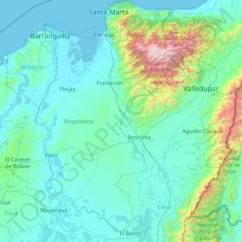
Name: Magdalena topographic map, elevation, terrain.
Location: Magdalena, Colombia (8.91711 -74.94559 11.34905 -73.54198)
Average elevation: 407 m
Minimum elevation: -1 m
Maximum elevation: 5,519 m
Other topographic maps
Click on a map to view its topography, its elevation and its terrain.
Centro Experimental Gaviotas
Gaviotas has leveraged many forms of solar energy. They developed solar heating panels to provide hot water, which were installed in Gaviotas homes and housing developments in Medellín. The original design was not suited for Bogotá, however, since at 2,600 meters of altitude (9,000 ft) the city has a cooler…
Average elevation: 176 m
Los Caobos;British Pub
Colombia > Norte de Santander > Cúcuta > Los Caobos;British Pub
Average elevation: 342 m
Santa Catalina
Colombia > Archipiélago de San Andrés, Providencia y Santa Catalina
Average elevation: 8 m
Floridablanca
Colombia > Santander > Floridablanca > Floridablanca
Floridablanca is situated at an altitude of about 925 metres (3,035 ft) in the Eastern Ranges of the Colombian Andes, though locally the topography varies greatly. To the east of the city the higher mountains of the Andes rise above the city, thrusted upwards by the north–south-trending Bucaramanga-Santa…
Average elevation: 1,091 m