
Udon Thani Province topographic map
Interactive map
Click on the map to display elevation.
About this map
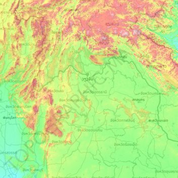
Name: Udon Thani Province topographic map, elevation, terrain.
Location: Udon Thani Province, Thailand (14.92119 100.06800 20.12119 105.26800)
Average elevation: 400 m
Minimum elevation: 7 m
Maximum elevation: 2,629 m
Other topographic maps
Click on a map to view its topography, its elevation and its terrain.
Thailand
Thailand comprises several distinct geographic regions, partly corresponding to the provincial groups. The north of the country is the mountainous area of the Thai highlands, with the highest point being Doi Inthanon in the Thanon Thong Chai Range at 2,565 metres (8,415 ft) elevation. The northeast, Isan,…
Average elevation: 156 m
Ban Luang Subdistrict Administrative Organization
Thailand > Phra Nakhon Si Ayutthaya Province
Average elevation: 5 m
Amphoe Rom Chamcha Fishing Pond
Thailand > Chiang Mai Province > Mae Hia > Ban Pa Chi
Average elevation: 331 m
Bangkok
Bangkok is in the Chao Phraya River delta in Thailand's central plain. The river meanders through the city in a southerly direction, emptying into the Gulf of Thailand approximately 25 kilometres (16 mi) south of city centre. The area is flat and low-lying, with an average elevation of 1.5 metres (4 ft 11 in)…
Average elevation: 3 m
Ban San Pu Loei
Thailand > Phayao Province > San Pa Muang Subdistrict > Ban San Pu Loei
Average elevation: 400 m
Don Ya Nang Subdistrict Administrative Organization
Thailand > Phra Nakhon Si Ayutthaya Province
Average elevation: 9 m
Pathum Thani Town Municipality
Thailand > Pathum Thani Province > Mueang Pathum Thani District
Average elevation: 5 m
Maha Phram Subdistrict Municipality
Thailand > Phra Nakhon Si Ayutthaya Province > Bang Ban District
Average elevation: 5 m
Khu Khot Town Municipality
Thailand > Pathum Thani Province > Lam Luk Ka District > Khu Khot Town Municipality
Average elevation: 5 m