
Chiang Mai Province topographic map
Interactive map
Click on the map to display elevation.
About this map
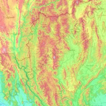
Name: Chiang Mai Province topographic map, elevation, terrain.
Location: Chiang Mai Province, Thailand (17.24833 98.08083 20.14758 99.57585)
Average elevation: 649 m
Minimum elevation: -1 m
Maximum elevation: 2,541 m
Other topographic maps
Click on a map to view its topography, its elevation and its terrain.
Mae Wang
Thailand > Chiang Mai Province
Mae Wang, Thung Satok, Chiang Mai Province, Thailand
Average elevation: 314 m
Mae Hia
Thailand > Chiang Mai Province
Mae Hia, San Phak Wan, Saraphi District, Chiang Mai Province, 50230, Thailand
Average elevation: 357 m
Ban Muang Kung
Thailand > Chiang Mai Province
Ban Muang Kung, San Phak Wan, Saraphi District, Chiang Mai Province, 50230, Thailand
Average elevation: 314 m
Mae Raem
Thailand > Chiang Mai Province
Mae Raem, Chiang Mai Province, 50180, Thailand
Average elevation: 573 m
Mae Chaem River
Thailand > Chiang Mai Province
Mae Chaem River, Hot District, Chiang Mai Province, 50240, Thailand
Average elevation: 877 m
Amphoe Rom Chamcha Fishing Pond
Thailand > Chiang Mai Province > Mae Hia > Ban Pa Chi
Amphoe Rom Chamcha Fishing Pond, Ban Pa Chi, Mae Hia, Nong Khwai, Chiang Mai Province, Thailand
Average elevation: 331 m
Ban Pa Daet North
Thailand > Chiang Mai Province
Ban Pa Daet North, Pa Daet, Saraphi District, Chiang Mai Province, 50100, Thailand
Average elevation: 304 m
San Pa Tong
Thailand > Chiang Mai Province
San Pa Tong, Yu Wa, Chiang Mai Province, 50120, Thailand
Average elevation: 300 m
Ban Luang
Thailand > Chiang Mai Province
Ban Luang, Chiang Mai Province, Thailand
Average elevation: 631 m
Chiang Mai
Thailand > Chiang Mai Province
Chiang Mai, Pa Daet, Saraphi District, Chiang Mai Province, 55520, Thailand
Average elevation: 424 m
Ban Pa Poe
Thailand > Chiang Mai Province > Saraphi District > Ban Bpa Bpoe
Ban Pa Poe, Ban Bpa Bpoe, Tha Wang Tan, Saraphi District, Chiang Mai Province, 50100, Thailand
Average elevation: 303 m
Ban Sisa Ati
Thailand > Chiang Mai Province > Ban Sisa Ati
Ban Sisa Ati, Chiang Mai Province, Thailand
Average elevation: 409 m
Lamhuai Phi Ba
Thailand > Chiang Mai Province > Chiang Mai
Lamhuai Phi Ba, Chiang Mai, Chiang Mai Province, Thailand
Average elevation: 529 m
Ban Khun Khlang
Thailand > Chiang Mai Province > Ban Khun Khlang
Ban Khun Khlang, Chiang Mai Province, Thailand
Average elevation: 1,392 m
Doi Pha Hom Pok National Park
Thailand > Chiang Mai Province > Ban Huey Mak Liam
Doi Pha Hom Pok National Park, ชม.3015, Ban Huey Mak Liam, Chiang Mai Province, Thailand
Average elevation: 847 m
Doi Suthep
Thailand > Chiang Mai Province > Chiang Mai
Doi Suthep, Chiang Mai, Chiang Mai Province, Thailand
Average elevation: 1,351 m