
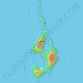
Ko Phi Phi Leh topographic map
Interactive map
Click on the map to display elevation.
About this map
Name: Ko Phi Phi Leh topographic map, elevation, terrain.
Location: Ko Phi Phi Leh, Krabi Province, Thailand (7.67135 98.76152 7.69933 98.77147)
Average elevation: 11 m
Minimum elevation: 0 m
Maximum elevation: 295 m
Other topographic maps
Click on a map to view its topography, its elevation and its terrain.
Phi Phi Islands
Thailand > Krabi Province > Haad Phak Nam
Phi Phi Islands, Haad Phak Nam, Krabi Province, Thailand
Average elevation: 3 m
Ban Ao Nang
Thailand > Krabi Province > Ban Ao Nang
Ban Ao Nang, Krabi Province, 8100, Thailand
Average elevation: 27 m
Laem Pho
Thailand > Krabi Province > Ao Nang
Laem Pho, Ao Nang, Krabi Province, Thailand
Average elevation: 8 m
Tub Keak
Thailand > Krabi Province > Tub Keak
Tub Keak, Krabi Province, Thailand
Average elevation: 72 m
Hang Nak Peak
Hang Nak Peak, Krabi Province, Thailand
Average elevation: 218 m
Ao Nang Beach
Thailand > Krabi Province > Ao Nang
Ao Nang Beach, Seafood Street, Ao Nang, Krabi Province, 8100, Thailand
Average elevation: 32 m