
Make a donation
Gear up for your next adventure:
As an Amazon Associate, this site earns from qualifying purchases at no extra cost to you.
Sam Ruean Subdistrict Administrative Organization topographic map
Click on the map to display elevation.
Make a donation
Gear up for your next adventure:
As an Amazon Associate, this site earns from qualifying purchases at no extra cost to you.
About this map
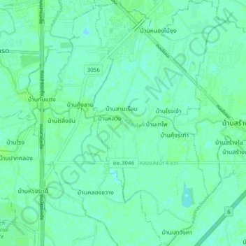
Name: Sam Ruean Subdistrict Administrative Organization topographic map, elevation, terrain.
Average elevation: 4 m
Minimum elevation: -1 m
Maximum elevation: 8 m
Make a donation
Gear up for your next adventure:
As an Amazon Associate, this site earns from qualifying purchases at no extra cost to you.
Other topographic maps
Click on a map to view its topography, its elevation and its terrain.
Phuket Province
Although some recent geographical works refer to the sections of the Tenasserim Hills in the isthmus as the "Phuket Range", these names are not found in classical geographic sources. Besides, the name Phuket is relatively recent having previously been named Jung Ceylon and Thalang. The highest elevation of the…
Average elevation: 24 m
Ban Khlong Prem
Thailand > Suan Phrik Thai Subdistrict Administrative Organization > Suan Phrik Thai Subdistrict
Average elevation: 4 m
Make a donation
Gear up for your next adventure:
As an Amazon Associate, this site earns from qualifying purchases at no extra cost to you.
Ban Khun Samut Chin
Thailand > Laem Fa Pha Subdistrict Administrative Organization > Laem Fa Pha Subdistrict
Average elevation: 1 m
Make a donation
Gear up for your next adventure:
As an Amazon Associate, this site earns from qualifying purchases at no extra cost to you.
Make a donation
Gear up for your next adventure:
As an Amazon Associate, this site earns from qualifying purchases at no extra cost to you.
Make a donation
Gear up for your next adventure:
As an Amazon Associate, this site earns from qualifying purchases at no extra cost to you.
Amphoe Rom Chamcha Fishing Pond
Thailand > Chiang Mai Province > Mae Hia > Ban Pa Chi
Average elevation: 331 m
Bang Duan Subdistrict Administrative Organization
Thailand > Samut Prakan Province
Average elevation: 11 m
Make a donation
Gear up for your next adventure:
As an Amazon Associate, this site earns from qualifying purchases at no extra cost to you.
Ban Khlong Nong Bon
Thailand > Samut Prakan Province > Racha Thewa Subdistrict Administrative Organization > Racha Thewa Subdistrict
Average elevation: 3 m
Make a donation
Gear up for your next adventure:
As an Amazon Associate, this site earns from qualifying purchases at no extra cost to you.
Make a donation
Gear up for your next adventure:
As an Amazon Associate, this site earns from qualifying purchases at no extra cost to you.
Ratchaburi Province
The area of Ratchaburi Province is divided into three parts. First, the border in the west which is shared with Myanmar and is about 60 kilometres (37 mi) long. The second contains the Tenasserim mountains and forests with an elevation of about 200–300 meters. The central area of the province is rich in…
Average elevation: 119 m
Make a donation
Gear up for your next adventure:
As an Amazon Associate, this site earns from qualifying purchases at no extra cost to you.
Ban Muang
Thailand > Phayao Province > Mueang Phayao District > Ban Mai Subdistrict > Ban Mai Nakhon > Ban Muang
Average elevation: 403 m
Make a donation
Gear up for your next adventure:
As an Amazon Associate, this site earns from qualifying purchases at no extra cost to you.
Bangkok
Bangkok is situated in the Chao Phraya River delta in Thailand's central plain. The river meanders through the city in a southerly direction, emptying into the Gulf of Thailand approximately 25 kilometres (16 mi) south of city centre. The area is flat and low-lying, with an average elevation of 1.5 metres (4…
Average elevation: 4 m
Make a donation
Gear up for your next adventure:
As an Amazon Associate, this site earns from qualifying purchases at no extra cost to you.
Khao Thongchai ca. 84 m เขาธงชัย
Thailand > Prachuap Khiri Khan Province > Ban Thung Ruea Yao
Average elevation: 6 m
Make a donation
Gear up for your next adventure:
As an Amazon Associate, this site earns from qualifying purchases at no extra cost to you.
Make a donation
Gear up for your next adventure:
As an Amazon Associate, this site earns from qualifying purchases at no extra cost to you.
Make a donation
Gear up for your next adventure:
As an Amazon Associate, this site earns from qualifying purchases at no extra cost to you.
Make a donation
Gear up for your next adventure:
As an Amazon Associate, this site earns from qualifying purchases at no extra cost to you.
Make a donation
Gear up for your next adventure:
As an Amazon Associate, this site earns from qualifying purchases at no extra cost to you.
Ban Pak Khlong Decho
Thailand > Samut Prakan Province > Preng Subdistrict Administrative Organization > Preng Subdistrict
Average elevation: 3 m
Make a donation
Gear up for your next adventure:
As an Amazon Associate, this site earns from qualifying purchases at no extra cost to you.