
Ratchaburi Province topographic map
Interactive map
Click on the map to display elevation.
Ratchaburi Province
The area of Ratchaburi Province is divided into three parts. First, the border in the west which is shared with Myanmar and is about 60 kilometres (37 mi) long. The second contains the Tenasserim mountains and forests with an elevation of about 200–300 meters. The central area of the province is rich in wetlands due to river flow. Ratchaburi has important natural resources are forest which it have area about 38 percent of the province. Moreover, it has minerals such as tin, tantalum, feldspar, quartz, limestone, and marlstone.
About this map
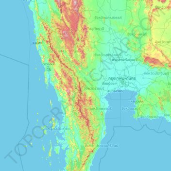
Name: Ratchaburi Province topographic map, elevation, terrain.
Location: Ratchaburi Province, Thailand (11.03179 96.75582 16.23179 101.95582)
Average elevation: 119 m
Minimum elevation: -3 m
Maximum elevation: 1,986 m
Other topographic maps
Click on a map to view its topography, its elevation and its terrain.
Thailand
Thailand comprises several distinct geographic regions, partly corresponding to the provincial groups. The north of the country is the mountainous area of the Thai highlands, with the highest point being Doi Inthanon in the Thanon Thong Chai Range at 2,565 metres (8,415 ft) elevation. The northeast, Isan,…
Average elevation: 156 m
Ban Luang Subdistrict Administrative Organization
Thailand > Phra Nakhon Si Ayutthaya Province
Average elevation: 5 m
Amphoe Rom Chamcha Fishing Pond
Thailand > Chiang Mai Province > Mae Hia > Ban Pa Chi
Average elevation: 331 m
Bangkok
Bangkok is in the Chao Phraya River delta in Thailand's central plain. The river meanders through the city in a southerly direction, emptying into the Gulf of Thailand approximately 25 kilometres (16 mi) south of city centre. The area is flat and low-lying, with an average elevation of 1.5 metres (4 ft 11 in)…
Average elevation: 3 m
Ban San Pu Loei
Thailand > Phayao Province > San Pa Muang Subdistrict > Ban San Pu Loei
Average elevation: 400 m
Don Ya Nang Subdistrict Administrative Organization
Thailand > Phra Nakhon Si Ayutthaya Province
Average elevation: 9 m
Pathum Thani Town Municipality
Thailand > Pathum Thani Province > Mueang Pathum Thani District
Average elevation: 5 m
Maha Phram Subdistrict Municipality
Thailand > Phra Nakhon Si Ayutthaya Province > Bang Ban District
Average elevation: 5 m
Khu Khot Town Municipality
Thailand > Pathum Thani Province > Lam Luk Ka District > Khu Khot Town Municipality
Average elevation: 5 m