
Torrance County topographic map
Interactive map
Click on the map to display elevation.
Torrance County
According to the U.S. Census Bureau, the county has a total area of 3,346 square miles (8,670 km2), of which 3,345 square miles (8,660 km2) is land and 0.9 square miles (2.3 km2) (0.03%) is water. Most of the county is gently-rolling grassland ranging from 6000 to 6200 feet in elevation. The Manzano Mountains rising to 10,098 feet on the western edge of the county provide it with its only significant topographic relief. The Manzano Wilderness area includes the highest part of the mountains. The other notable geographic feature of the county is the series of playas and seasonal lakes centering on Laguna del Perro southeast of Estancia.
About this map
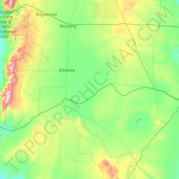
Name: Torrance County topographic map, elevation, terrain.
Location: Torrance County, New Mexico, United States (34.25968 -106.47122 35.04214 -105.29014)
Average elevation: 1,983 m
Minimum elevation: 1,725 m
Maximum elevation: 3,035 m
Other topographic maps
Click on a map to view its topography, its elevation and its terrain.
City of Rocks State Park
United States > New Mexico > Grant County
The City of Rocks State Park is also home to two main hiking trails: the Hydra trail, the Table Mountain trail, and the newly added Cienega Trail. The Hydra trail is 3.3 miles long with an elevation gain of 164ft. The Table Mountain trail is 3 miles long with an elevation gain of 695 ft. And the Cienega is…
Average elevation: 1,596 m
Alamogordo
United States > New Mexico > Otero County > Alamogordo
As of 2010, Alamogordo had a total area of 19.3 square miles (50.0 km2), all land. The city is located at an elevation of 4,330 feet (1,320 m) on the western flank of the Sacramento Mountains and on the eastern edge of the Tularosa Basin. It lies within the Rio Grande rift and in the northernmost part of the…
Average elevation: 1,716 m
Albuquerque
United States > New Mexico > Bernalillo County > Albuquerque
Located in north-central New Mexico, Albuquerque serves as the county seat of Bernalillo County. To its east are the Sandia–Manzano Mountains, Rio Grande flows north to south through its center, while the West Mesa and Petroglyph National Monument make up the western part of the city. Albuquerque has one of…
Average elevation: 1,671 m
Glenwood Hills
United States > New Mexico > Bernalillo County > Albuquerque > Glenwood Hills
Average elevation: 1,937 m