
Providence County topographic map
Interactive map
Click on the map to display elevation.
About this map
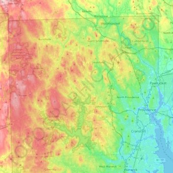
Name: Providence County topographic map, elevation, terrain.
Location: Providence County, Rhode Island, United States (41.72456 -71.79920 42.01894 -71.31774)
Average elevation: 108 m
Minimum elevation: -7 m
Maximum elevation: 272 m
Other topographic maps
Click on a map to view its topography, its elevation and its terrain.
Sandy Point
United States > Rhode Island > South County > Westerly
Sandy Point, Westerly, South County, Rhode Island, United States
Average elevation: 1 m
Richmond
United States > Rhode Island > South County
Richmond, South County, Rhode Island, United States
Average elevation: 56 m
Greenville
United States > Rhode Island > Providence County > Greenville
Greenville, Providence County, Rhode Island, 02828, United States
Average elevation: 98 m
Foster
United States > Rhode Island > Providence County
Foster, Providence County, Rhode Island, 02825, United States
Average elevation: 171 m
Newport
United States > Rhode Island > Newport County
Newport, Newport County, Rhode Island, 02840, United States
Average elevation: 8 m
West Warwick
United States > Rhode Island > Kent County
West Warwick, Kent County, Rhode Island, 02893, United States
Average elevation: 60 m
North Kingstown
United States > Rhode Island > South County
North Kingstown, South County, Rhode Island, United States
Average elevation: 35 m
Maple Road
United States > Rhode Island > Bristol County > Warren
Maple Road, Warren, Bristol County, Rhode Island, United States
Average elevation: 4 m
South County
South County, Rhode Island, United States
Average elevation: 30 m
Little Compton
United States > Rhode Island > Newport County
Little Compton, Newport County, Rhode Island, United States
Average elevation: 9 m
Westerly
United States > Rhode Island > Washington County
Westerly, Washington County, Rhode Island, 02808, United States
Average elevation: 19 m
West Greenwich
United States > Rhode Island > Kent County
West Greenwich, Kent County, Rhode Island, 02817, United States
Average elevation: 111 m
Central Falls
United States > Rhode Island > Central Falls
Central Falls, Providence County, Rhode Island, United States
Average elevation: 22 m
Kenyon
United States > Rhode Island > South County > Richmond > Kenyon
Kenyon, Richmond, South County, Rhode Island, 02836, United States
Average elevation: 41 m
Providence
United States > Rhode Island > Providence County
Providence, Providence County, Rhode Island, United States
Average elevation: 19 m
West Kingston
United States > Rhode Island > South County > South Kingstown > West Kingston
West Kingston, South Kingstown, South County, Rhode Island, 02881, United States
Average elevation: 41 m
Kent County
Kent County, Rhode Island, United States
Average elevation: 92 m
Cummock Island
United States > Rhode Island > South County > South Kingstown
Cummock Island, South Kingstown, South County, Rhode Island, United States
Average elevation: 9 m
Woonsocket
United States > Rhode Island > Providence County
Woonsocket, Providence County, Rhode Island, 02895, United States
Average elevation: 74 m
Narragansett
United States > Rhode Island > South County
Narragansett, South County, Rhode Island, 02882, United States
Average elevation: 12 m
East Greenwich
United States > Rhode Island > Kent County
East Greenwich, Kent County, Rhode Island, 02818, United States
Average elevation: 21 m
South Kingstown
United States > Rhode Island > South County
South Kingstown, South County, Rhode Island, United States
Average elevation: 30 m
Cranston
United States > Rhode Island > Providence County
Cranston, Providence County, Rhode Island, United States
Average elevation: 27 m
Newport County
Newport County, Rhode Island, United States
Average elevation: 14 m