
Make a donation
Gear up for your next adventure:
As an Amazon Associate, this site earns from qualifying purchases at no extra cost to you.
South County topographic map
Click on the map to display elevation.
Make a donation
Gear up for your next adventure:
As an Amazon Associate, this site earns from qualifying purchases at no extra cost to you.
South County
According to the U.S. Census Bureau, the county has a total area of 563 square miles (1,460 km2), of which 329 square miles (850 km2) is land and 234 square miles (610 km2) (41%) is water. It is the largest county in Rhode Island by total area. The county's topography ranges from flat along the shoreline to gently rolling hills farther inland. The highest point is a large area approximately 560 feet (171 m) above sea level in the Exeter neighborhood of Black Plain; the lowest point is sea level along the coast. The northern boundary west of Davisville is approximately 41.60°N. The western boundary north of Westerly is approximately 71.79°W.
Make a donation
Gear up for your next adventure:
As an Amazon Associate, this site earns from qualifying purchases at no extra cost to you.
About this map
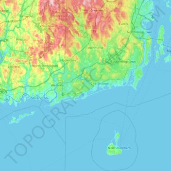
Name: South County topographic map, elevation, terrain.
Location: South County, Rhode Island, United States (41.09583 -71.90743 41.65531 -71.38209)
Average elevation: 30 m
Minimum elevation: -5 m
Maximum elevation: 196 m
Make a donation
Gear up for your next adventure:
As an Amazon Associate, this site earns from qualifying purchases at no extra cost to you.
Other topographic maps
Click on a map to view its topography, its elevation and its terrain.
West Kingston
United States > Rhode Island > South County > South Kingstown > West Kingston
Average elevation: 41 m
Make a donation
Gear up for your next adventure:
As an Amazon Associate, this site earns from qualifying purchases at no extra cost to you.