
Make a donation
Gear up for your next adventure:
As an Amazon Associate, this site earns from qualifying purchases at no extra cost to you.
Kent County topographic map
Click on the map to display elevation.
Make a donation
Gear up for your next adventure:
As an Amazon Associate, this site earns from qualifying purchases at no extra cost to you.
About this map
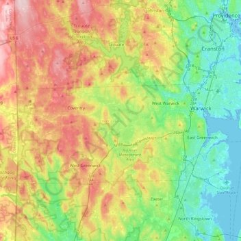
Name: Kent County topographic map, elevation, terrain.
Location: Kent County, Rhode Island, United States (41.59675 -71.78970 41.76833 -71.35666)
Average elevation: 92 m
Minimum elevation: -7 m
Maximum elevation: 241 m
Make a donation
Gear up for your next adventure:
As an Amazon Associate, this site earns from qualifying purchases at no extra cost to you.
Other topographic maps
Click on a map to view its topography, its elevation and its terrain.
West Kingston
United States > Rhode Island > South County > South Kingstown > West Kingston
Average elevation: 41 m
Make a donation
Gear up for your next adventure:
As an Amazon Associate, this site earns from qualifying purchases at no extra cost to you.