
Make a donation
Gear up for your next adventure:
As an Amazon Associate, this site earns from qualifying purchases at no extra cost to you.
Ayeyarwady River topographic map
Click on the map to display elevation.
Make a donation
Gear up for your next adventure:
As an Amazon Associate, this site earns from qualifying purchases at no extra cost to you.
Ayeyarwady River
The streams of the Nmai and Mali that form the Irrawaddy originate in high and remote mountains near the border with Tibet. This part of Myanmar, which extends north from Myitkyina and the Irrawaddy confluence, lies entirely outside the tropics. Rain falls at all seasons of the year, but mostly in the summer. The valleys and lower hill ranges are covered with tropical and subtropical evergreen rainforest instead of monsoon (deciduous) forest. This region is characterised by subtropical and temperate forests of oak and pine are found at elevations above 900 metres (3,000 ft). This evergreen forest passes into sub-tropical pine forest at about 1,500 metres (4,900 ft) feet. Above 1,800 metres (5,900 ft), are forests of rhododendrons, and that in turn into evergreen conifer forest above 2,400 metres (7,900 ft) feet.
Make a donation
Gear up for your next adventure:
As an Amazon Associate, this site earns from qualifying purchases at no extra cost to you.
About this map
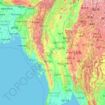
Name: Ayeyarwady River topographic map, elevation, terrain.
Location: Ayeyarwady River, Myanmar (16.11401 94.67093 25.70966 97.53597)
Average elevation: 438 m
Minimum elevation: -3 m
Maximum elevation: 3,525 m
Make a donation
Gear up for your next adventure:
As an Amazon Associate, this site earns from qualifying purchases at no extra cost to you.
Other topographic maps
Click on a map to view its topography, its elevation and its terrain.
Make a donation
Gear up for your next adventure:
As an Amazon Associate, this site earns from qualifying purchases at no extra cost to you.
Make a donation
Gear up for your next adventure:
As an Amazon Associate, this site earns from qualifying purchases at no extra cost to you.
Make a donation
Gear up for your next adventure:
As an Amazon Associate, this site earns from qualifying purchases at no extra cost to you.
Pyin Oo Lwin
Pyin Oo Lwin or Pyin U Lwin (Burmese: ပြင်ဦးလွင်မြို့; MLCTS: prang u: lwang mrui., pronounced [pjɪ̀ɰ̃ ʔú lwɪ̀ɰ̃]; Shan: ဝဵင်းပၢင်ႇဢူႈ), formerly and colloquially referred to as Maymyo (Burmese: မေမြို့; MLCTS: me mrui.), is a…
Average elevation: 913 m
Make a donation
Gear up for your next adventure:
As an Amazon Associate, this site earns from qualifying purchases at no extra cost to you.
Pyin Oo Lwin
Pyin Oo Lwin or Pyin U Lwin (Burmese: ပြင်ဦးလွင်မြို့; MLCTS: prang u: lwang mrui., pronounced [pjɪ̀ɰ̃ ʔú lwɪ̀ɰ̃]; Shan: ဝဵင်းပၢင်ႇဢူႈ, Weng Pang U), formerly and colloquially referred to as Maymyo (Burmese: မေမြို့; MLCTS: me…
Average elevation: 913 m
Pyin Oo Lwin
Pyin Oo Lwin or Pyin U Lwin (Burmese: ပြင်ဦးလွင်မြို့, MLCTS: prang u: lwang mrui., pronounced [pjɪ̀ɰ̃ ʔú lwɪ̀ɰ̃]; Shan: ဝဵင်းပၢင်ႇဢူႈ, Weng Pang U), formerly and colloquially referred to as Maymyo (Burmese: မေမြို့, MLCTS: me…
Average elevation: 913 m
Make a donation
Gear up for your next adventure:
As an Amazon Associate, this site earns from qualifying purchases at no extra cost to you.
Taunggyi
Myanmar > Shan State > Taunggyi District
Taunggyi (Burmese: တောင်ကြီးမြို့, MLCTS: taung kri: mrui. [tàʊɰ̃dʑí mjo̰]) is the capital and largest city of Shan State, Myanmar (Burma); and lies on the Thazi-Kyaingtong road at an elevation of 4,712 feet (1,436 m), just north of Shwenyaung and Inle Lake within the Myelat…
Average elevation: 1,151 m
Pyin Oo Lwin
Pyin Oo Lwin or Pyin U Lwin (Burmese: ပြင်ဦးလွင်မြို့, MLCTS: prang u: lwang mrui., pronounced [pjɪ̀ɰ̃ ʔú lwɪ̀ɰ̃]; Shan: ဝဵင်းပၢင်ႇဢူႈ, Weng Pang U), formerly and colloquially referred to as Maymyo (Burmese: မေမြို့, MLCTS: me…
Average elevation: 913 m
Make a donation
Gear up for your next adventure:
As an Amazon Associate, this site earns from qualifying purchases at no extra cost to you.
Pyin Oo Lwin
Pyin Oo Lwin or Pyin U Lwin (Burmese: ပြင်ဦးလွင်မြို့, MLCTS: prang u: lwang mrui., pronounced [pjɪ̀ɰ̃ ʔú lwɪ̀ɰ̃]; Shan: ဝဵင်းပၢင်ႇဢူႈ, Weng Pang U), formerly and colloquially referred to as Maymyo (Burmese: မေမြို့, MLCTS: me…
Average elevation: 913 m
Taungoo
Myanmar > Bago Region > Taungoo District
Three mountain ranges traverse the district—the Pegu Yomas, the Karen Hills, and the Nat Ma Taung or "Great Watershed"—all of which have a north and south direction, and are covered for the most part with dense forest. The Pegu Yomas have a general elevation of from 800 to 1,200 feet (240 to 370 m), while…
Average elevation: 47 m
Make a donation
Gear up for your next adventure:
As an Amazon Associate, this site earns from qualifying purchases at no extra cost to you.
Kalaw
Myanmar > Shan State > Kalaw District
The hill station is located at an elevation of 1310 metres, 50 km from the Inle lake. Kalaw is famous for hiking and trekking. Many trekking trails ranging from nearby places to Inle Lake and Pindaya. The town still feels like a high-altitude holiday resort – the air is cool, the atmosphere is calm and the…
Average elevation: 1,366 m
Make a donation
Gear up for your next adventure:
As an Amazon Associate, this site earns from qualifying purchases at no extra cost to you.
Make a donation
Gear up for your next adventure:
As an Amazon Associate, this site earns from qualifying purchases at no extra cost to you.
Make a donation
Gear up for your next adventure:
As an Amazon Associate, this site earns from qualifying purchases at no extra cost to you.
Make a donation
Gear up for your next adventure:
As an Amazon Associate, this site earns from qualifying purchases at no extra cost to you.
Make a donation
Gear up for your next adventure:
As an Amazon Associate, this site earns from qualifying purchases at no extra cost to you.
Make a donation
Gear up for your next adventure:
As an Amazon Associate, this site earns from qualifying purchases at no extra cost to you.
Taunggyi
Myanmar > Shan State > Taunggyi District
Taunggyi (Burmese: တောင်ကြီးမြို့, MLCTS: taung kri: mrui. [tàʊɰ̃dʑí mjo̰]) is the capital and largest city of Shan State, Myanmar (Burma); and lies on the Thazi-Kyaingtong road at an elevation of 4,712 feet (1,436 m), just north of Shwenyaung and Inle Lake within the Myelat…
Average elevation: 1,151 m
Make a donation
Gear up for your next adventure:
As an Amazon Associate, this site earns from qualifying purchases at no extra cost to you.
Thin Bon Kyun
Myanmar > Tanintharyi Region > Launglon Township > Thin Pone Kyun
Average elevation: 16 m
Make a donation
Gear up for your next adventure:
As an Amazon Associate, this site earns from qualifying purchases at no extra cost to you.
Make a donation
Gear up for your next adventure:
As an Amazon Associate, this site earns from qualifying purchases at no extra cost to you.
Make a donation
Gear up for your next adventure:
As an Amazon Associate, this site earns from qualifying purchases at no extra cost to you.
Make a donation
Gear up for your next adventure:
As an Amazon Associate, this site earns from qualifying purchases at no extra cost to you.
Make a donation
Gear up for your next adventure:
As an Amazon Associate, this site earns from qualifying purchases at no extra cost to you.
Make a donation
Gear up for your next adventure:
As an Amazon Associate, this site earns from qualifying purchases at no extra cost to you.
Make a donation
Gear up for your next adventure:
As an Amazon Associate, this site earns from qualifying purchases at no extra cost to you.
Make a donation
Gear up for your next adventure:
As an Amazon Associate, this site earns from qualifying purchases at no extra cost to you.
Make a donation
Gear up for your next adventure:
As an Amazon Associate, this site earns from qualifying purchases at no extra cost to you.
Make a donation
Gear up for your next adventure:
As an Amazon Associate, this site earns from qualifying purchases at no extra cost to you.
Make a donation
Gear up for your next adventure:
As an Amazon Associate, this site earns from qualifying purchases at no extra cost to you.