Geolocate

Hsipaw topographic map

Click on the map to display elevation.

About this map

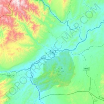
Name: Hsipaw topographic map, elevation, terrain.

Location: Hsipaw, Hsipaw Township, Kyaukme District, Shan State, Myanmar (22.45969 97.13928 22.77969 97.45928)

Average elevation: 710 m

Minimum elevation: 387 m

Maximum elevation: 1,897 m

Other topographic maps

Click on a map to view its topography, its elevation and its terrain.

Namtu Township

Myanmar > Shan State > Kyaukme District

Average elevation: 887 m

Namtu Township

Myanmar > Shan State > Kyaukme District

Average elevation: 887 m

Gear up for your next adventure:

🧳Compression Sacks - Maximize space in your backpack by shrinking gear
🥾Trail Hiking Boots - Supportive boots for rough trails
🥘Camping Cookware Set - Compact nesting pots and pans for trail cooking
🌬️Windproof Camp Stove - Efficient cooking even on exposed mountain peaks
🛏️Camping Sleeping Mat - Comfortable mats for sleeping outdoors

As an Amazon Associate, this site earns from qualifying purchases at no extra cost to you.