
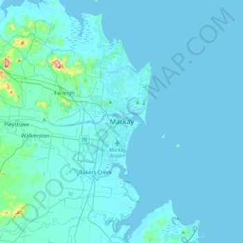
Mackay topographic map
Interactive map
Click on the map to display elevation.
About this map
Name: Mackay topographic map, elevation, terrain.
Location: Mackay, Mackay Regional, Queensland, 4740, Australia (-21.30196 149.02651 -20.98196 149.34651)
Average elevation: 13 m
Minimum elevation: -3 m
Maximum elevation: 291 m
Other topographic maps
Click on a map to view its topography, its elevation and its terrain.
Boyne Valley
Boyne Valley, Gladstone Regional, Queensland, Australia
Average elevation: 283 m
Mount Gravatt
Mount Gravatt, Greater Brisbane, Queensland, Australia
Average elevation: 68 m
Queenton
Queenton, Charters Towers Regional, Queensland, Australia
Average elevation: 297 m
West Prairie
West Prairie, Toowoomba Regional, Queensland, Australia
Average elevation: 363 m
Fraser Coast Regional
Fraser Coast Regional, Queensland, Australia
Average elevation: 38 m
New Farm
New Farm, Greater Brisbane, Queensland, 4005, Australia
Average elevation: 12 m
Noosa North Shore
Noosa North Shore, Noosa Shire, Queensland, Australia
Average elevation: 27 m
Mornington Island
Mornington Island, Queensland, Australia
Average elevation: 3 m
Poona
Poona, Fraser Coast Regional, Queensland, Australia
Average elevation: 5 m
Great Wall
Great Wall, Cloncurry Shire, Queensland, Australia
Average elevation: 354 m
Allan Creek
Allan Creek, Scenic Rim Regional, Queensland, Australia
Average elevation: 108 m
Lockyer Valley Regional
Lockyer Valley Regional, Queensland, Australia
Average elevation: 360 m
Dulacca
Dulacca, Western Downs Regional, Queensland, Australia
Average elevation: 328 m
Digby Island
Digby Island, The Percy Group, Isaac Regional, Queensland, Australia
Average elevation: 4 m
Flinton
Flinton, Western Downs Regional, Queensland, Australia
Average elevation: 240 m
McCoy Creek
Australia > Queensland > Bundaberg Region > Bundaberg
McCoy Creek, Avoca, Oakwood, Bundaberg, Bundaberg Region, Queensland, Australia
Average elevation: 11 m
Banyo
Australia > Queensland > Brisbane City
Banyo, Brisbane City, Queensland, 4014, Australia
Average elevation: 8 m
Mondure
Mondure, South Burnett Regional, Queensland, Australia
Average elevation: 287 m
Girraween
Girraween, Southern Downs Regional, Queensland, Australia
Average elevation: 1,000 m
Thulimbah
Thulimbah, Southern Downs Regional, Queensland, 4376, Australia
Average elevation: 904 m
Cushnie
Cushnie, South Burnett Regional, Queensland, Australia
Average elevation: 426 m
Windaroo
Australia > Queensland > Logan City
Windaroo, Logan City, Queensland, Australia
Average elevation: 27 m
Edmonton
Australia > Queensland > Cairns
Edmonton, Cairns, Cairns Regional, Queensland, 4869, Australia
Average elevation: 96 m
Kedron
Australia > Queensland > Brisbane City
Kedron, Brisbane City, Queensland, 4031, Australia
Average elevation: 28 m
Kippa-Ring
Kippa-Ring, Greater Brisbane, Moreton Bay Regional, Queensland, 4021, Australia
Average elevation: 6 m
Roma
Roma, Maranoa Regional, Queensland, 4455, Australia
Average elevation: 315 m
Grange Heights
Australia > Queensland > Brisbane City
Grange Heights, Alderley, Brisbane City, Queensland, 4051, Australia
Average elevation: 34 m
Coal Creek
Coal Creek, Somerset Regional, Queensland, Australia
Average elevation: 143 m
Yeppoon
Yeppoon, Livingstone Shire, Queensland, Australia
Average elevation: 37 m
Great Dividing Range
Great Dividing Range, The Falls, Southern Downs Regional, Queensland, Australia
Average elevation: 939 m
Kallangur
Kallangur, Greater Brisbane, Moreton Bay Regional, Queensland, 4503, Australia
Average elevation: 28 m
Amiens
Amiens, Southern Downs Regional, Queensland, Australia
Average elevation: 877 m
Gladstone Harbour
Gladstone Harbour, Gladstone Regional, Queensland, Australia
Average elevation: 8 m
Bell
Bell, Western Downs Regional, Queensland, Australia
Average elevation: 498 m
Birtinya
Australia > Queensland > Sunshine Coast Regional
Birtinya, Sunshine Coast Regional, Queensland, Australia
Average elevation: 3 m
Tudu Island
Tudu Island, Coral Sea, Torres Shire, Queensland, Australia
Average elevation: 0 m
Isis River
Australia > Queensland > Bundaberg Region > Buxton
Isis River, Cherwell, Buxton, Fraser Coast Regional, Bundaberg Region, Queensland, Australia
Average elevation: 12 m
Sunshine Coast Regional
Sunshine Coast Regional, Queensland, Australia
Average elevation: 56 m
Clayfield
Australia > Queensland > Brisbane City
Clayfield, Brisbane City, Queensland, Australia
Average elevation: 22 m
Sunshine Coast
Australia > Queensland > Sunshine Coast Regional
Sunshine Coast, Sunshine Coast Regional, Queensland, Australia
Average elevation: 109 m
Ravenshoe
Ravenshoe, Tablelands Regional, Queensland, Australia
Average elevation: 965 m
Southern Downs Regional
Southern Downs Regional, Queensland, Australia
Average elevation: 594 m
Hervey Bay
Australia > Queensland > Hervey Bay
Hervey Bay, Queensland, 4655, Australia
Average elevation: 6 m
Campbells Pocket
Campbells Pocket, Greater Brisbane, Moreton Bay Regional, Queensland, Australia
Average elevation: 288 m
Indooroopilly
Australia > Queensland > Brisbane City
Indooroopilly, Brisbane City, Queensland, 4068, Australia
Average elevation: 26 m