
Birtinya topographic map
Click on the map to display elevation.
About this map
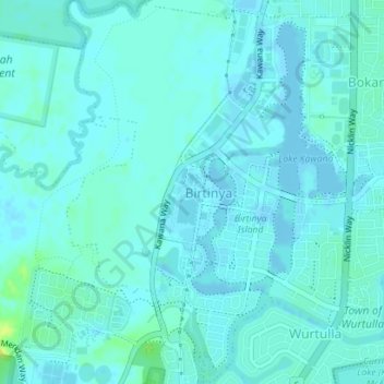
Name: Birtinya topographic map, elevation, terrain.
Location: Birtinya, Sunshine Coast Regional, Queensland, Australia (-26.76090 153.10282 -26.72954 153.12844)
Average elevation: 3 m
Minimum elevation: -4 m
Maximum elevation: 17 m
Other topographic maps
Click on a map to view its topography, its elevation and its terrain.
Sunshine Coast
Australia > Queensland > Sunshine Coast Regional
The Sunshine Coast in Queensland, Australia, showcases a diverse topography that harmoniously blends coastal plains with rugged hinterlands. Along its eastern edge, the region features expansive sandy beaches and coastal dunes that transition smoothly into fertile lowlands. Inland, the terrain becomes more…
Average elevation: 109 m