Geolocate

Pianezza topographic map

Click on the map to display elevation.

About this map

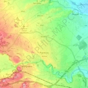
Name: Pianezza topographic map, elevation, terrain.

Location: Pianezza, Turin, Piedmont, 10044, Italy (45.08812 7.51433 45.13624 7.60737)

Average elevation: 317 m

Minimum elevation: 264 m

Maximum elevation: 383 m

Other topographic maps

Click on a map to view its topography, its elevation and its terrain.

Pratobotrile

Italy > Piedmont > Turin > Condove

Average elevation: 1,117 m

Turin

Italy > Piedmont > Turin

Average elevation: 295 m

Turin

Italy > Piedmont > Turin

Average elevation: 295 m

Rivetto

Italy > Piedmont > Turin > San Giorio di Susa

Average elevation: 583 m

Magnoletto

Italy > Piedmont > Turin > Condove

Average elevation: 699 m

Tornetti

Italy > Piedmont > Turin > Viù

Average elevation: 1,333 m

Baio Dora

Italy > Piedmont > Turin

Average elevation: 494 m

Famolasco

Italy > Piedmont > Turin

Average elevation: 508 m

Morelli

Italy > Piedmont > Turin > Gravere

Average elevation: 785 m

La Cialma

Italy > Piedmont > Turin > Locana

Average elevation: 1,705 m

Turin

Italy > Piedmont > Turin

Average elevation: 295 m

Belvedere

Italy > Piedmont > Turin > Borgiallo

Average elevation: 733 m

Gear up for your next adventure:

🔦LED Headlamp - Hands-free lighting for early morning starts or late finishes
🧰Multitool Knife - Compact and versatile tool for outdoor use
🧦Merino Wool Socks - Moisture-wicking comfort for long-distance hiking
🧥Thermal Fleece Jacket - Versatile insulation for changing mountain temperatures
🧭GPS Outdoor Watch - Smart watch for navigation and fitness tracking in nature

As an Amazon Associate, this site earns from qualifying purchases at no extra cost to you.