
Ovalle topographic map
Click on the map to display elevation.
About this map
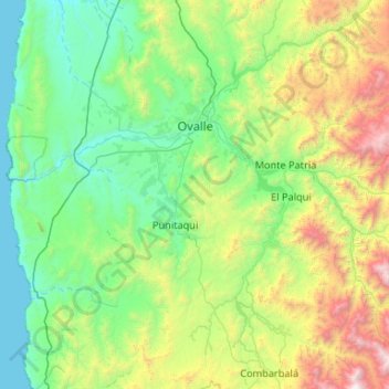
Name: Ovalle topographic map, elevation, terrain.
Location: Ovalle, Provincia de Limarí, Región de Coquimbo, Chile (-31.21650 -71.71563 -30.31047 -70.85303)
Average elevation: 765 m
Minimum elevation: 0 m
Maximum elevation: 3,718 m
Other topographic maps
Click on a map to view its topography, its elevation and its terrain.
Altar Bajo
Chile > Región de Coquimbo > Provincia de Limarí > Punitaqui > Altar Bajo
Average elevation: 825 m
Valle Hermoso
Chile > Región de Coquimbo > Provincia de Limarí > Combarbalá
Average elevation: 1,232 m
Mialqui
Chile > Región de Coquimbo > Provincia de Limarí > Monte Patria > Chilecito
Average elevation: 699 m
Potrerillos
Chile > Región de Coquimbo > Provincia de Limarí > Combarbalá > Potrerillos
Average elevation: 1,117 m
La Cisterna
Chile > Región de Coquimbo > Provincia de Limarí > Monte Patria > Tulahuén > La Cisterna
Average elevation: 1,149 m
Potrerillos Altos
Chile > Región de Coquimbo > Provincia de Limarí > Ovalle > Nueva Aurora > Potrerillos Altos
Average elevation: 339 m
La Cebada
Chile > Región de Coquimbo > Provincia de Limarí > Ovalle > La Cebada
Average elevation: 84 m
Las Mollacas
Chile > Región de Coquimbo > Provincia de Limarí > Monte Patria
Average elevation: 1,340 m
La Puntilla
Chile > Región de Coquimbo > Provincia de Limarí > Río Hurtado > Pichasca
Average elevation: 853 m
Embalse Valle Hermoso
Chile > Región de Coquimbo > Provincia de Limarí > Combarbalá
Average elevation: 1,705 m
Río Mostazal
Chile > Región de Coquimbo > Provincia de Limarí > Monte Patria
Average elevation: 1,650 m
Cerrillos de Tamaya
Chile > Región de Coquimbo > Provincia de Limarí > Ovalle
Average elevation: 256 m
Chañaral Alto
Chile > Región de Coquimbo > Provincia de Limarí > Monte Patria
Average elevation: 574 m
Cerrillos de Rapel
Chile > Región de Coquimbo > Provincia de Limarí > Monte Patria
Average elevation: 853 m
Plaza de Armas de Ovalle
Chile > Región de Coquimbo > Provincia de Limarí > Ovalle
Average elevation: 229 m
Las Higueras
Chile > Región de Coquimbo > Provincia de Limarí > Monte Patria
Average elevation: 1,839 m
El Codito
Chile > Región de Coquimbo > Provincia de Limarí > Combarbalá > Cogotí
Average elevation: 871 m