
El Palqui topographic map
Click on the map to display elevation.
About this map
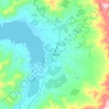
Name: El Palqui topographic map, elevation, terrain.
Average elevation: 568 m
Minimum elevation: 374 m
Maximum elevation: 1,217 m
Other topographic maps
Click on a map to view its topography, its elevation and its terrain.
Parque Nacional Bosque de Fray Jorge
Chile > Región de Coquimbo > Provincia de Limarí > Ovalle
Average elevation: 172 m
Embalse Cogotí
Chile > Región de Coquimbo > Provincia de Limarí > Combarbalá > La Ligua
Average elevation: 770 m
Embalse Valle Hermoso
Chile > Región de Coquimbo > Provincia de Limarí > Combarbalá
Average elevation: 1,705 m
Río Mostazal
Chile > Región de Coquimbo > Provincia de Limarí > Monte Patria
Average elevation: 1,650 m