Geolocate

Cuestecita topographic map

Click on the map to display elevation.

About this map

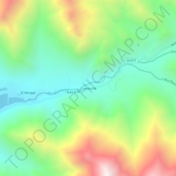
Name: Cuestecita topographic map, elevation, terrain.

Location: Cuestecita, Monte Patria, Provincia de Limarí, Región de Coquimbo, Chile (-30.83854 -70.64198 -30.79854 -70.60198)

Average elevation: 1,549 m

Minimum elevation: 1,093 m

Maximum elevation: 2,359 m

Other topographic maps

Click on a map to view its topography, its elevation and its terrain.

Gear up for your next adventure:

🔨Vehicle Emergency Tool - Safety tool for remote road trips to trailheads
🌬️Windproof Camp Stove - Efficient cooking even on exposed mountain peaks
🥾Light Hiking Boots - Lightweight and comfortable boots for day hikes
Camping Groundsheet - Protect your tent from moisture and dirt
👟Trail Running Shoes - Agile footwear for fast-paced topographic exploration

As an Amazon Associate, this site earns from qualifying purchases at no extra cost to you.