
Embalse Recoleta topographic map
Click on the map to display elevation.
About this map
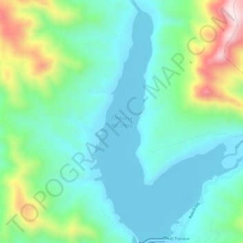
Name: Embalse Recoleta topographic map, elevation, terrain.
Average elevation: 523 m
Minimum elevation: 378 m
Maximum elevation: 951 m
Other topographic maps
Click on a map to view its topography, its elevation and its terrain.
Parque Nacional Bosque de Fray Jorge
Chile > Región de Coquimbo > Provincia de Limarí > Ovalle
Average elevation: 172 m
Potrerillos Altos
Chile > Región de Coquimbo > Provincia de Limarí > Ovalle > Nueva Aurora > Potrerillos Altos
Average elevation: 339 m
La Cebada
Chile > Región de Coquimbo > Provincia de Limarí > Ovalle > La Cebada
Average elevation: 84 m
Cerrillos de Tamaya
Chile > Región de Coquimbo > Provincia de Limarí > Ovalle
Average elevation: 256 m
Plaza de Armas de Ovalle
Chile > Región de Coquimbo > Provincia de Limarí > Ovalle
Average elevation: 229 m