Geolocate

Mirhama topographic map

Click on the map to display elevation.

About this map

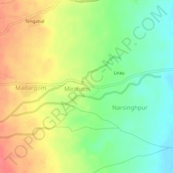
Name: Mirhama topographic map, elevation, terrain.

Location: Mirhama, Kulgam, Jammu and Kashmir, India (33.64338 74.95910 33.64715 74.96685)

Average elevation: 1,805 m

Minimum elevation: 1,775 m

Maximum elevation: 1,838 m

Other topographic maps

Click on a map to view its topography, its elevation and its terrain.

Pambai

India > Jammu and Kashmir > Kulgam

Average elevation: 1,856 m

Pariwan

India > Jammu and Kashmir > Kulgam

Average elevation: 1,885 m

Madargom

India > Jammu and Kashmir > Kulgam

Average elevation: 1,824 m

Khanabal

India > Jammu and Kashmir > Kulgam

Average elevation: 1,597 m

Yaripora

India > Jammu and Kashmir > Kulgam

Average elevation: 1,672 m

Tirigom

India > Jammu and Kashmir > Kulgam

Average elevation: 1,716 m

Yaripora

India > Jammu and Kashmir > Kulgam

Average elevation: 1,672 m

Frisal

India > Jammu and Kashmir > Kulgam

Average elevation: 1,624 m

Tirigom

India > Jammu and Kashmir > Kulgam

Average elevation: 1,716 m

Gear up for your next adventure:

Tent Footprint - Protect tent floor and increase durability
🦯Trekking Poles - Reduced impact on joints for steep topographic climbs
🧭GPS Handheld Device - Reliable GPS navigation for outdoor adventures
🔋Emergency Crank Radio - Weather alerts and power without needing batteries
💧Collapsible Water Bottle - Space-saving water bottle for outdoor activities

As an Amazon Associate, this site earns from qualifying purchases at no extra cost to you.