Geolocate

Madargom topographic map

Click on the map to display elevation.

About this map

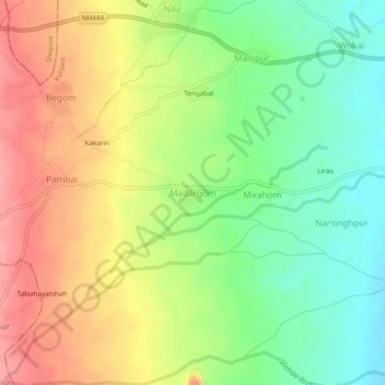
Name: Madargom topographic map, elevation, terrain.

Location: Madargom, Kulgam, Jammu and Kashmir, India (33.62511 74.93426 33.66511 74.97426)

Average elevation: 1,824 m

Minimum elevation: 1,778 m

Maximum elevation: 1,875 m

Other topographic maps

Click on a map to view its topography, its elevation and its terrain.

Kulgam

India > Jammu and Kashmir > Kulgam

Average elevation: 1,732 m

Mirhama

India > Jammu and Kashmir > Kulgam

Average elevation: 1,805 m

Nillow

India > Jammu and Kashmir > Kulgam

Average elevation: 1,824 m

Kulgam

India > Jammu and Kashmir > Kulgam

Average elevation: 1,732 m

Gear up for your next adventure:

💧Filtered Water Bottle - Safe drinking water on the go
🥾Trail Hiking Shoes - Durable shoes designed for rugged trails
🧢Sun Protection Cap - Breathable cap to protect from sun exposure
🔭Compact Binoculars - Lightweight optics for scouting trails and wildlife
🥾Mountain Trail Shoes - High-traction shoes for mountain trails

As an Amazon Associate, this site earns from qualifying purchases at no extra cost to you.