Geolocate

Yaripora topographic map

Click on the map to display elevation.

About this map

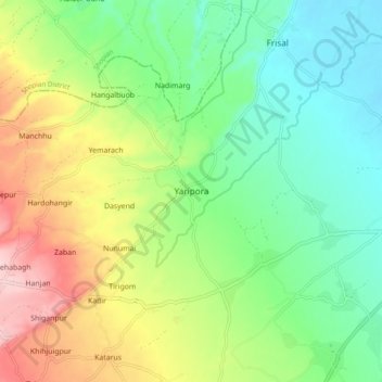
Name: Yaripora topographic map, elevation, terrain.

Location: Yaripora, Kulgam, Jammu and Kashmir, 192232, India (33.68244 74.97689 33.76244 75.05689)

Average elevation: 1,672 m

Minimum elevation: 1,593 m

Maximum elevation: 1,810 m

Other topographic maps

Click on a map to view its topography, its elevation and its terrain.

Kulgam

India > Jammu and Kashmir > Kulgam

Average elevation: 1,732 m

Mirhama

India > Jammu and Kashmir > Kulgam

Average elevation: 1,805 m

Nillow

India > Jammu and Kashmir > Kulgam

Average elevation: 1,824 m

Kulgam

India > Jammu and Kashmir > Kulgam

Average elevation: 1,732 m

Gear up for your next adventure:

🥾Hiking Gaiters - Protect legs and shoes from mud, snow, and debris
🛏️Camping Sleeping Mat - Comfortable mats for sleeping outdoors
🧢Hiking Sun Hat - Wide-brimmed protection for exposed mountain ridges
🥾Light Hiking Boots - Lightweight and comfortable boots for day hikes
🥾Hiking Boots - Sturdy boots providing ankle support and traction on rugged trails

As an Amazon Associate, this site earns from qualifying purchases at no extra cost to you.