Geolocate

Frisal topographic map

Click on the map to display elevation.

About this map

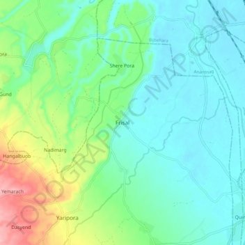
Name: Frisal topographic map, elevation, terrain.

Location: Frisal, Kulgam, Jammu and Kashmir, 192232, India (33.71348 74.99858 33.79348 75.07858)

Average elevation: 1,624 m

Minimum elevation: 1,591 m

Maximum elevation: 1,721 m

Other topographic maps

Click on a map to view its topography, its elevation and its terrain.

Kulgam

India > Jammu and Kashmir > Kulgam

Average elevation: 1,732 m

Mirhama

India > Jammu and Kashmir > Kulgam

Average elevation: 1,805 m

Nillow

India > Jammu and Kashmir > Kulgam

Average elevation: 1,824 m

Kulgam

India > Jammu and Kashmir > Kulgam

Average elevation: 1,732 m

Gear up for your next adventure:

🔭Compact Binoculars - Lightweight optics for scouting trails and wildlife
🛶Kayak Dry Bag - Waterproof storage for kayaking adventures
🛶Canoe Life Vest - Safety vest for water sports
Lightweight Backpacking Tent - Compact tent for efficient hiking trips
🥾Waterproof Hiking Shoes - Durable shoes for wet and rugged trails

As an Amazon Associate, this site earns from qualifying purchases at no extra cost to you.