Geolocate

Tirigom topographic map

Click on the map to display elevation.

About this map

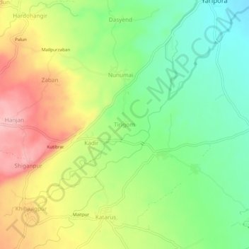
Name: Tirigom topographic map, elevation, terrain.

Location: Tirigom, Kulgam, Jammu and Kashmir, 192232, India (33.68248 74.97947 33.72248 75.01947)

Average elevation: 1,716 m

Minimum elevation: 1,649 m

Maximum elevation: 1,801 m

Other topographic maps

Click on a map to view its topography, its elevation and its terrain.

Kulgam

India > Jammu and Kashmir > Kulgam

Average elevation: 1,732 m

Mirhama

India > Jammu and Kashmir > Kulgam

Average elevation: 1,805 m

Nillow

India > Jammu and Kashmir > Kulgam

Average elevation: 1,824 m

Kulgam

India > Jammu and Kashmir > Kulgam

Average elevation: 1,732 m

Gear up for your next adventure:

❄️Traction Ice Cleats - Slip-on spikes for icy trails and winter hiking
🧦Thermal Socks - Warm socks for winter hiking or camping
🔦LED Headlamp - Hands-free lighting for early morning starts or late finishes
🔭Compact Binoculars - Lightweight optics for scouting trails and wildlife
Family Camping Tent - Spacious tent suitable for family camping trips

As an Amazon Associate, this site earns from qualifying purchases at no extra cost to you.