
Make a donation
Gear up for your next adventure:
As an Amazon Associate, this site earns from qualifying purchases at no extra cost to you.
Córdoba topographic map
Click on the map to display elevation.
Make a donation
Gear up for your next adventure:
As an Amazon Associate, this site earns from qualifying purchases at no extra cost to you.
Córdoba
The differences in elevation in the Valley are very small, ranging from 100 and 170 metres above sea level, with the city proper located at an average altitude of roughly 125 metres above sea level. The landscape of the valley is further subdivided in the piedmont connecting with the Sierra, the fluvial terraces and the most immediate vicinity of the river course.
Make a donation
Gear up for your next adventure:
As an Amazon Associate, this site earns from qualifying purchases at no extra cost to you.
About this map
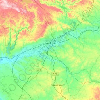
Name: Córdoba topographic map, elevation, terrain.
Location: Córdoba, Andalusia, Spain (37.66582 -4.99860 38.03152 -4.35143)
Average elevation: 281 m
Minimum elevation: 64 m
Maximum elevation: 878 m
Make a donation
Gear up for your next adventure:
As an Amazon Associate, this site earns from qualifying purchases at no extra cost to you.
Other topographic maps
Click on a map to view its topography, its elevation and its terrain.
Mijas
Spain > Andalusia > Costa del Sol Occidental > Mijas > Mijas
The climate changes gradually with increasing elevation in the mountains. Temperatures can drop to 10 °C (50 °F). In the peaks, over 600 m (2,000 ft) high, some ice may form in winter, while precipitation increases to almost 800 mm (32 in).
Average elevation: 447 m
Park Beach
Spain > Andalusia > Costa del Sol Occidental > Estepona > Park Beach
Average elevation: 13 m
Make a donation
Gear up for your next adventure:
As an Amazon Associate, this site earns from qualifying purchases at no extra cost to you.