Geolocate

Oria topographic map

Click on the map to display elevation.

About this map

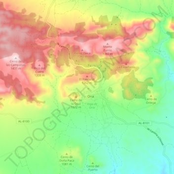
Name: Oria topographic map, elevation, terrain.

Location: Oria, Valle del Almanzora, Almeria, Andalusia, Spain (37.44834 -2.33463 37.52834 -2.25463)

Average elevation: 1,066 m

Minimum elevation: 783 m

Maximum elevation: 1,435 m

Gear up for your next adventure:

🧴Waterproofing Spray - Restore the DWR coating on jackets and tents
🧤Thermal Hiking Gloves - Grip-enhanced gloves for cold-weather altitude trekking
🍽️Titanium Camping Spork - Ultralight and indestructible eating utensil
Camping Tent - Weather-resistant tents suitable for 2 to 6 people
🦶Anti-Blister Balm - Prevents friction and hotspots during long ascents

As an Amazon Associate, this site earns from qualifying purchases at no extra cost to you.