Geolocate

Alfaix topographic map

Click on the map to display elevation.

About this map

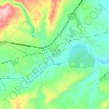
Name: Alfaix topographic map, elevation, terrain.

Location: Alfaix, Los Gallardos, Almeria, Andalusia, 04280, Spain (37.12289 -1.97908 37.16289 -1.93908)

Average elevation: 160 m

Minimum elevation: 63 m

Maximum elevation: 354 m

Gear up for your next adventure:

🚑Survival Whistle - Signal for help across long distances in mountains
👟Sport Hiking Sandals - Breathable footwear for water crossings and camp rest
🏃Hydration Running Vest - Carry water and maps close to your body for speed
🍽️Titanium Camping Spork - Ultralight and indestructible eating utensil
🥾Mountain Hiking Boots - High-traction boots for rocky terrain

As an Amazon Associate, this site earns from qualifying purchases at no extra cost to you.