
Make a donation
Gear up for your next adventure:
As an Amazon Associate, this site earns from qualifying purchases at no extra cost to you.
Alhaurín el Grande topographic map
Click on the map to display elevation.
Make a donation
Gear up for your next adventure:
As an Amazon Associate, this site earns from qualifying purchases at no extra cost to you.
About this map
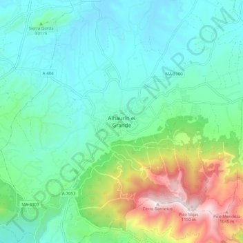
Name: Alhaurín el Grande topographic map, elevation, terrain.
Average elevation: 337 m
Minimum elevation: 71 m
Maximum elevation: 1,142 m
Make a donation
Gear up for your next adventure:
As an Amazon Associate, this site earns from qualifying purchases at no extra cost to you.
Other topographic maps
Click on a map to view its topography, its elevation and its terrain.
Alhaurín el Grande
Spain > Andalusia > Valle del Guadalhorce > Alhaurín el Grande
Average elevation: 291 m
Cártama
Spain > Andalusia > Valle del Guadalhorce
The original town, Cártama Pueblo, stretches across the steep side of the Hill of the Virgin (240 m over the sea level). Its buildings and roads follow the contours of the hill, and reflect the varied topography of the area.
Average elevation: 173 m
Make a donation
Gear up for your next adventure:
As an Amazon Associate, this site earns from qualifying purchases at no extra cost to you.
Make a donation
Gear up for your next adventure:
As an Amazon Associate, this site earns from qualifying purchases at no extra cost to you.